An online project under the direction of the CAPE ANN MUSEUM
Catalogue Entry
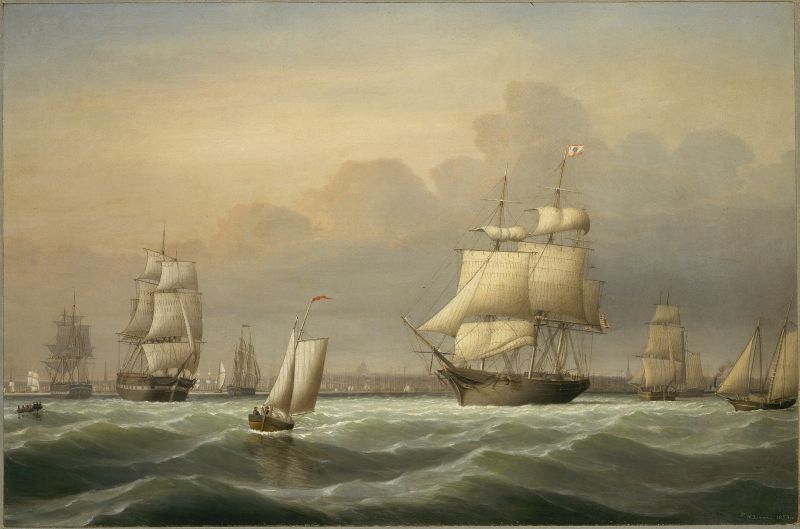
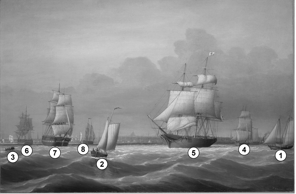
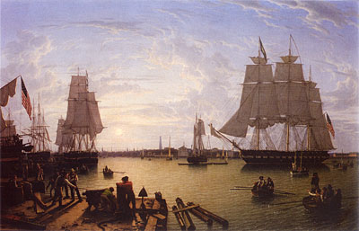
Viewed on a breezy afternoon, against the Boston skyline from Governor’s Island, the lively vessel activity in this painting sets it apart from Lane’s other—more placid—Boston Harbor scenes. As a storm looms in the west, a fishing schooner (1) and a schooner-boat (2) are moving briskly under shortened sail; nor is the choppy sea making the work of rowing easy for the oarsmen in the yawl-boat (3). The larger vessels as well are feeling the wind’s strength.
The half-brig (4) sailing downwind is deep-loaded, and her crew will be grateful for the added stability when she comes up into the wind to tack—as tack she must, to avoid the East Boston flats. The clipper ship (5) is setting her fore course and the fore and main topgallant sails as she makes her departure from Boston, but will probably not set more sail until clear of the outer harbor.
In painting the three packet ships in the left background. the artist seems to have intended less to illustrate any particular harbor situations than to show three maneuvers under sail. (6) is head to the wind; main topsail aback; the fore square sails clewed-up, as if coming to anchor. (7) is sailing downwind under shortened sail; the main course, spanker, and mizzen topgallant sail all furled. (8) is close-hauled under all plain sail, as if oblivious to wind conditions and a busy harbor.
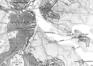
This painting’s skyline is likely based on a drawing that was subsequently modified or partially replaced to provide updated details for paintings subsequent to 1853-54. Lane’s drawing, Boston Harbor, 1850s (inv. 158), using Governor’s Island as his viewing point, offers a very similar view of the post 1853 skyline; however, it is missing a sheet that would have adjoined the middle sheet at its right margin, and would have included Boston’s North End and the prominent steeple of Old North Church. The viewpoint map for Boston Harbor, 1850s (inv. 158) (see below) shows where this panel would join. It also shows where the church would have appeared on that missing sheet.
This painting marks the beginning of a continuity in Lane’s depiction of Boston Harbor. He had found a view of the city skyline that was comprehensive in coverage while offering interesting detail when used in part.
– Erik Ronnberg
- Subject Types
: - Vessel Types
: - Massachusetts Locales
: - Activities of People
: - Rowing »
- Objects
:
Historical Materials
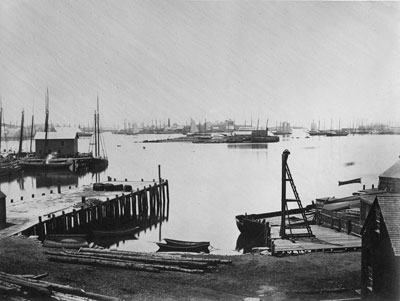
During the years after the war of 1812 and before the Civil War, the port of Boston was a center of American deep-water shipping. Trading with China, India, and the West Indies, which had fueled maritime growth in the early years of the century gave way to re-exporting these goods and foreign trade based on the shoe and textile trades. Although second to New York in terms of shipping tonnage, many of New York's shipbuilders and merchants were Boston based. In addition, ship building continued in Boston. Also, the coastal trade (the domestic trade up and down the coast) was still the most efficient way to transport goods and passengers, and accounts for much of the tonnage and shipping traffic.
Although dwarfed by New York, Boston was an active port in the 1840s and 1850s. Its registered tonnage rose from 149,186 in 1840 to 270,510 in 1850. The harbor was a crowded place. For example, on September 18, 1850, 32 ships, 49 barks, 47 brigs, and 52 schooners were reported at Boston.(1)
In 1849, foreign entries at Boston included 215 ships, 305 barks, 908 brigs, and 52 schooners. Coastwise arrivals included 193 ships, 488 barks, 1087 brigs, 4287 schooners, 89 sloops, and 65 schooners.(2)
(1) W.H. Bunting, p.8.
(2) Ibid.
For more information:
Samuel Eliot Morrison, The Maritime History of Massachusetts, 1783-1860
W.H. Bunting, Portrait of a Port, Boston 1852-1914 Cambridge: The Belknap Press of Harvard University, 1971.
Printed map inside Boston Almanac
Published by B. B. Mussey & Co. and Thomas Groom, Boston
Cape Ann Museum Library & Archive (R910.45 B65 1848)
Map at front of almanac with Tremont Temple highlighted.
Also filed under: Boston City Views » // Maps » // Tremont Temple »
Harvard Depository: Widener (NAV 578.57)
For digitized version, click here.
Also filed under: Signal Systems (Flags & Maritime Codes) »
Tinted lithograph with hand coloring
13 7/8 x 22 3/8 in.
Boston Athenaeum
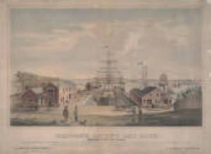
From Sally Pierce and Catharina Slautterback, Boston Lithography, 1825–1880: The Boston Atheneaum Collection (Boston: Athenaeum, 1991): "Tidd drew this print when he was a consulting engineer for Simpson's. He has depicted the clipper ship 'Southern Cross' in the dry dock. Built in 1851, she was known for having sailed from San Francisco to Hong Kong in the record breaking time of thirty-two days. The Bethlehem Ship Building Company eventually took over this location and operated a dry dock there until the mid 1940s."
Also filed under: "Southern Cross" (Clipper Ship) » // M. M. Tidd, Lith. – Boston »
Library of Congress Catalog Number 2004671768
Also filed under: "Britannia" (Cunard Steamship) »
1853
Bostonian Society (1884.0209)
Also filed under: Scott, John W. A. »
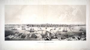
1 print : lithograph, tinted ; image 50.3 x 111.9 cm., 68.7 x 121.2 cm.
View of the city of Boston from East Boston showing Boston Harbor. The wharves of East Boston can be seen in the foreground.
Number nine of thirty-eight city views published in "Whitefield's Original Views of (North) American Cities (Scenery).
On stone by Charles W. Burton after a drawing by Edwin Whitefield.
Inscribed in brown ink lower right corner of sheet: "Boston Athenaeum from Josiah Quincy. September 28, 1848."
Local Notes:#1848.1.
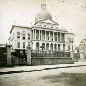
The "new" State House is located across from the Boston Common on the top of Beacon Hill, and serves as the Massachusetts state capital. The land was once owned by Massachusetts's first elected governor, John Hancock. Charles Bullfinch was the architect of the building, which was completed in 1798.
The dome was originally roofed with wood shingles, which leaked. In 1802 it was covered with copper by Paul Revere's Revere Copper Company. The dome was first painted gray and then light yellow before being gilded with gold leaf in 1874.
lithograph
1832
"Salmon pinxt" at lower left; "Pendleton, Boston" at lower right
Also filed under: Pendleton's, Lith. – Boston » // Salmon, Robert »
Lithograph
Published by N. Currier, New York
Library of Congress Catalog Number 2002698122
Also filed under: Currier (& Ives) – New York »
In general, brigs were small to medium size merchant vessels, generally ranging between 80 and 120 feet in hull length. Their hull forms ranged from sharp-ended (for greater speed; see Brig "Antelope" in Boston Harbor, 1863 (inv. 43)) to “kettle-bottom” (a contemporary term for full-ended with wide hull bottom for maximum cargo capacity; see Ships in Ice off Ten Pound Island, Gloucester, 1850s (inv. 44) and Boston Harbor, c.1850 (inv. 48)). The former were widely used in the packet trade (coastwise or transoceanic); the latter were bulk-carriers designed for long passages on regular routes. (1) This rig was favored by Gloucester merchants in the Surinam Trade, which led to vessels so-rigged being referred to by recent historians as Surinam brigs (see Brig "Cadet" in Gloucester Harbor, late 1840s (inv. 13) and Gloucester Harbor at Dusk, c.1852 (inv. 563)). (2)
Brigs are two-masted square-rigged vessels which fall into three categories:
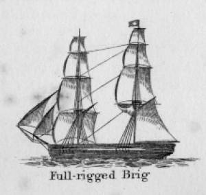
Full-rigged brigs—simply called brigs—were fully square-rigged on both masts. A sub-type—called a snow—had a trysail mast on the aft side of the lower main mast, on which the spanker, with its gaff and boom, was set. (3)
Brigantines were square-rigged on the fore mast, but set only square topsails on the main mast. This type was rarely seen in America in Lane’s time, but was still used for some naval vessels and European merchant vessels. The term is commonly misapplied to hermaphrodite brigs. (4)
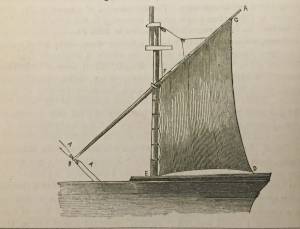
Hermaphrodite brigs—more commonly called half-brigs by American seamen and merchants—were square-rigged only on the fore mast, the main mast being rigged with a spanker and a gaff-topsail. Staysails were often set between the fore and main masts, there being no gaff-rigged sail on the fore mast.
– Erik Ronnberg
References:
1. Howard I. Chapelle, The National Watercraft Collection (Washington, DC: Smithsonian Institution, 1960), 64–68.
2. Alfred Mansfield Brooks, Gloucester Recollected: A Familiar History (Gloucester, MA: Peter Smith, 1974), 62–74. A candid and witty view of Gloucester’s Surinam Trade, which employed brigs and barks.
3. R[ichard] H[enry] Dana, Jr., The Seaman's Friend (Boston: Thomas Groom & Co., 1841. 13th ed., 1873), 100 and Plate 4 and captions; and M.H. Parry, et al., Aak to Zumbra: A Dictionary of the World's Watercraft (Newport News, VA: The Mariners’ Museum, 2000), 95.
4. Parry, 95, see Definition 1.
Oil on canvas
17 1/4 x 25 3/4 in.
Cape Ann Museum, Gloucester, Mass., Gift of Isabel Babson Lane, 1946 (1147.a)
Photo: Cape Ann Museum
Detail of brig "Cadet."
Also filed under: "Cadet" (Brig) »
Painting on board
72 x 48 in.
Collection of Erik Ronnberg
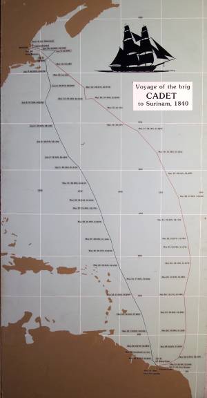
Chart showing the voyage of the brig Cadet to Surinam and return, March 10–June 11, 1840.
Also filed under: "Cadet" (Brig) » // Surinam Trade »

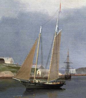
Schooners in Lane’s time were, with few exceptions, two-masted vessels carrying a fore-and-aft rig having one or two jibs, a fore staysail, gaff-rigged fore- and main sails, and often fore- and main topsails. One variant was the topsail schooner, which set a square topsail on the fore topmast. The hulls of both types were basically similar, their rigs having been chosen for sailing close to the wind. This was an advantage in the coastal trade, where entering confined ports required sailing into the wind and frequent tacking. The square topsail proved useful on longer coastwise voyages, the topsail providing a steadier motion in offshore swells, reducing wear and tear on canvas from the slatting of the fore-and-aft sails. (1)
Schooners of the types portrayed by Lane varied in size from 70 to 100 feet on deck. Their weight was never determined, and the term “tonnage” was a figure derived from a formula which assigned an approximation of hull volume for purposes of imposing duties (port taxes) oncargoes and other official levies. (2)
Crews of smaller schooners numbered three or four men. Larger schooners might carry four to six if a lengthy voyage was planned. The relative simplicity of the rig made sail handling much easier than on a square-rigged vessel. Schooner captains often owned shares in their vessels, but most schooners were majority-owned by land-based firms or by individuals who had the time and business connections to manage the tasks of acquiring and distributing the goods to be carried. (3)
Many schooners were informally “classified” by the nature of their work or the cargoes they carried, the terminology coined by their owners, agents, and crews—even sometimes by casual bystanders. In Lane’s lifetime, the following terms were commonly used for the schooner types he portrayed:
Fishing Schooners: While the port of Gloucester is synonymous with fishing and the schooner rig, Lane depicted only a few examples of fishing schooners in a Gloucester setting. Lane’s early years coincided with the preeminence of Gloucester’s foreign trade, which dominated the harbor while fishing was carried on from other Cape Ann communities under far less prosperous conditions than later. Only by the early 1850s was there a re-ascendency of the fishing industry in Gloucester Harbor, documented in a few of Lane’s paintings and lithographs. Depictions of fishing schooners at sea and at work are likewise few. Only A Smart Blow, c.1856 (inv. 9), showing cod fishing on Georges Bank (4), and At the Fishing Grounds, 1851 (inv. 276), showing mackerel jigging on Georges Bank, are known examples. (5)
– Erik Ronnberg
References:
1. Howard I. Chapelle, The History of American Sailing Ships (New York: W.W. Norton & Co., 1935), 258. While three-masted schooners were in use in Lane’s time, none have appeared in his surviving work; and Charles S. Morgan, “New England Coasting Schooners”, The American Neptune 23, no. 1 (DATE): 5–9, from an article which deals mostly with later and larger schooner types.
2. John Lyman, “Register Tonnage and its Measurement”, The American Neptune V, nos. 3–4 (DATE). American tonnage laws in force in Lane’s lifetime are discussed in no. 3, pp. 226–27 and no. 4, p. 322.
3. Ship Registers of the District of Gloucester, Massachusetts, 1789–1875 (Salem, MA: The Essex Institute, 1944). Vessels whose shipping or fishing voyages included visits to foreign ports were required to register with the Federal Customs agent at their home port. While the vessel’s trade or work was unrecorded, their owners and master were listed, in addition to registry dimensions and place where built. Records kept by the National Archives can be consulted for information on specific voyages and ports visited.
4. Howard I. Chapelle, The National Watercraft Collection (Washington, DC: Smithsonian Institution, 1960), 74–76.
5. Howard I. Chapelle, The American Fishing Schooners (New York: W.W. Norton & Co., 1973), 58–75, 76–101.
1852
Oil on canvas
28 x 48 1/2 in.
Cape Ann Museum, Gloucester, Mass., Deposited by the City of Gloucester, 1952. Given to the city by Mrs. Julian James in memory of her grandfather Sidney Mason, 1913 (DEP. 200)
Detail of fishing schooner.
Also filed under: Gloucester Harbor, Inner / Harbor Cove »
c.1865 Stereograph card Frank Rowell, Publisher stereo image, "x " on card, "x" Cape Ann Museum Library & Archive
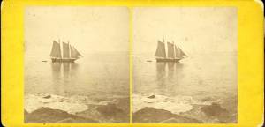
View showing a sharpshooter fishing schooner, circa 1850. Note the stern davits for a yawl boat, which is being towed astern in this view.
Also filed under: Historic Photographs »
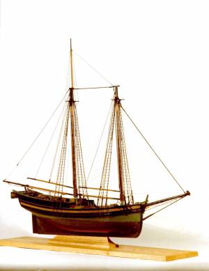
Model made for marine artist Thomas M. Hoyne
scale: 3/8" = 1'
Thomas M. Hoyne Collection, Mystic Seaport, Conn.
While this model was built to represent a typical Marblehead fishing schooner of the early nineteenth century, it has the basic characteristics of other banks fishing schooners of that region and period: a sharper bow below the waterline and a generally more sea-kindly hull form, a high quarter deck, and a yawl-boat on stern davits.
The simple schooner rig could be fitted with a fore topmast and square topsail for making winter trading voyages to the West Indies. The yawl boat was often put ashore and a "moses boat" shipped on the stern davits for bringing barrels of rum and molasses from a beach to the schooner.
– Erik Ronnberg
References:
Jeffrey Bolster, Black Jacks: African American Seafarers in the Age of Sail (Cambridge, MA: Harvard University Press, 1997).
Howard I. Chapelle, American Small Sailing Craft (New York: W.W. Norton & Co., 1951), 29–31.
Also filed under: Hand-lining » // Ship Models »

20 x 14 in.
Cape Ann Museum Library & Archive, Gloucester, Mass.
The image, as originally drafted, showed only spars and sail outlines with dimensions, and an approximate deck line. The hull is a complete overdrawing, in fine pencil lines with varied shading, all agreeing closely with Lane's drawing style and depiction of water. Fishing schooners very similar to this one can be seen in his painting /entry:240/.
– Erik Ronnberg
Newspaper
"Shipping Intelligence: Port of Gloucester"
"Fishermen . . . The T. [Tasso] was considerably injured by coming in contact with brig Deposite, at Salem . . ."
Also filed under: Newspaper / Journal Articles »
Newsprint
From bound volume owned by publisher Francis Procter
Collection of Fred and Stephanie Buck
"A Prize Race—We have heard it intimated that some of our fishermen intend trying the merits of their "crack" schooners this fall, after the fishing season is done. Why not! . . .Such a fleet under full press of sail, would be worth going many a mile to witness; then for the witchery of Lane's matchless pencil to fix the scene upon canvass. . ."
Also filed under: Fishing » // Newspaper / Journal Articles »
Also filed under: Cape Ann Advertiser Masthead »

c.1870 Stereograph card Procter Brothers, Publisher Cape Ann Museum Library & Archive
"Gloucester Harbor from Rocky Neck, Looking Southwest. This gives a portion of the Harbor lying between Ten Pound Island and Eastern Point. At the time of taking this picture the wind was from the northeast, and a large fleet of fishing and other vessels were in the harbor. In the range of the picture about one hundred vessels were at anchor. In the small Cove in the foreground quite a number of dories are moored. Eastern Point appears on the left in the background."
Southeast Harbor was known for being a safe harbor.
Also filed under: Gloucester Harbor, Outer » // Historic Photographs » // Rocky Neck » // Small Craft – Wherries, and Dories »
1870s Stereograph card Cape Ann Museum Library & Archive
"Said schooner was captured about the first of September, 1871, by Capt. Torry, of the Dominion Cutter 'Sweepstakes,' for alleged violation of the Fishery Treaty. She was gallantly recaptured from the harbor of Guysboro, N.S., by Capt. Harvey Knowlton., Jr., (one of her owners,) assisted by six brave seamen, on Sunday night, Oct. 8th. The Dominion Government never asked for her return, and the United States Government very readily granted her a new set of papers."
Also filed under: Fishing » // Historic Photographs » // Waterfront, Gloucester »
1876 Photograph Cape Ann Museum Library & Archive
Also filed under: Gloucester Harbor, Inner / Harbor Cove » // Historic Photographs » // Waterfront, Gloucester »

c.1870 Cape Ann Museum Library & Archive (2013.068)
Schooner fleet anchored in the inner harbor. Looking east from Rocky Neck, Duncan's Point wharves and Lane house (at far left), Sawyer School cupola on Friend Street.
Also filed under: Duncan's Point » // Gloucester Harbor, Inner / Harbor Cove » // Historic Photographs » // Waterfront, Gloucester »
See p. 254.
As Erik Ronnberg has noted, Lane's engraving follows closely the French publication, Jal's "Glossaire Nautique" of 1848.
Also filed under: Babson History of the Town of Gloucester »
Wood, cordage, acrylic paste, metal
~40 in. x 30 in.
Erik Ronnberg
Model shows mast of fishing vessel being unstepped.
Also filed under: Burnham Brothers Marine Railway » // Fishing »

Watercolor on paper
8 3/4 x 19 3/4 in.
Cape Ann Museum, Gloucester, Mass., Gift of Rev. and Mrs. A. A. Madsen, 1950
Accession # 1468
Fishing schooners in Gloucester's outer harbor, probably riding out bad weather.
Also filed under: Elwell, D. Jerome » // Gloucester Harbor, Outer »

1876 Photograph Cape Ann Museum Library & Archive
Ignatius Weber's windmill (now defunct) is shown.
Also filed under: Flake Yard » // Fort (The) and Fort Point » // Gloucester Harbor, Inner / Harbor Cove » // Historic Photographs » // Rogers's (George H.) wharves » // Waterfront, Gloucester » // Windmill »
Print from bound volume of Gloucester scenes sent to the Philadelphia Centennial Exhibition.
11 x 14 in.
Cape Ann Museum Library & Archives
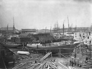
Schooner "Grace L. Fears" at David A. Story Yard in Vincent's Cove.
Also filed under: Historic Photographs » // Shipbuilding / Repair » // Vincent's Cove »
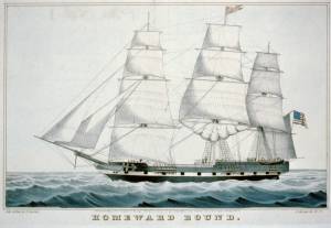
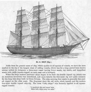
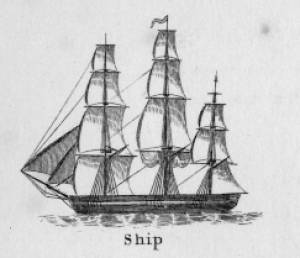
The term "ship," as used by nineteenth-century merchants and seamen, referred to a large three-masted sailing vessel which was square-rigged on all three masts. (1) In that same period, sailing warships of the largest classes were also called ships, or more formally, ships of the line, their size qualifying them to engage the enemy in a line of battle. (2) In the second half of the nineteenth century, as sailing vessels were replaced by engine-powered vessels, the term ship was applied to any large vessel, regardless of propulsion or use. (3)
Ships were often further defined by their specialized uses or modifications, clipper ships and packet ships being the most noted examples. Built for speed, clipper ships were employed in carrying high-value or perishable goods over long distances. (4) Lane painted formal portraits of clipper ships for their owners, as well as generic examples for his port paintings. (5)
Packet ships were designed for carrying capacity which required some sacrifice in speed while still being able to make scheduled passages within a reasonable time frame between regular destinations. In the packet trade with European ports, mail, passengers, and bulk cargos such as cotton, textiles, and farm produce made the eastward passages. Mail, passengers (usually in much larger numbers), and finished wares were the usual cargos for return trips. (6) Lane depicted these vessels in portraits for their owners, and in his port scenes of Boston and New York Harbors.
Ships in specific trades were often identified by their cargos: salt ships which brought salt to Gloucester for curing dried fish; tea clippers in the China Trade; coffee ships in the West Indies and South American trades, and cotton ships bringing cotton to mills in New England or to European ports. Some trades were identified by the special destination of a ship’s regular voyages; hence Gloucester vessels in the trade with Surinam were identified as Surinam ships (or barks, or brigs, depending on their rigs). In Lane’s Gloucester Harbor scenes, there are likely (though not identifiable) examples of Surinam ships, but only the ship "California" in his depiction of the Burnham marine railway in Gloucester (see Three Master on the Gloucester Railways, 1857 (inv. 29)) is so identified. (7)
– Erik Ronnberg
References:
1. R[ichard)] H[enry] Dana, Jr., The Seaman’s Friend, 13th ed. (Boston: Thomas Groom & Co., 1873), p. 121 and Plate IV with captions.
2. A Naval Encyclopaedia (Philadelphia: L. R. Hamersly & Co., 1884), 739, 741.
3. M.H. Parry, et al., Aak to Zumbra: A Dictionary of the World’s Watercraft (Newport News, VA: The Mariners’ Museum, 2000), 536.
4. Howard I. Chapelle, The History of American Sailing Ships (New York: W.W. Norton & Co., 1935), 281–87.
5. Ibid.
6. Howard I. Chapelle, The National Watercraft Collection (Washington, DC: Smithsonian Institution, 1960), 26–30.
7. Alfred Mansfield Brooks, Gloucester Recollected: A Familiar History (Gloucester, MA: Peter Smith, 1974), 67–69.
Photograph
From American Clipper Ships 1833–1858, by Octavius T. Howe and Frederick C. Matthews, vol. 1 (Salem, MA: Marine Research Society, 1926).
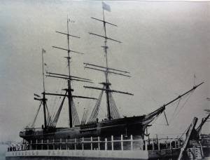
Photo caption reads: "'Golden State' 1363 tons, built at New York, in 1852. From a photograph showing her in dock at Quebec in 1884."
Also filed under: "Golden State" (Clipper Ship) »
_sm.jpg)

Oil on canvas
24 x 35 in.
Peabody Essex Museum, Salem, Mass.
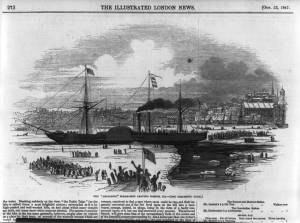
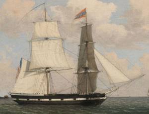
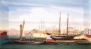
Walters' painting depicts the "Nonantum" homeward bound for Boston from Liverpool in 1842. The paddle-steamer is one of the four Clyde-built Britannia-class vessels, of which one is visible crossing in the opposite direction.
View related catalogue entries (2) »
Also filed under: Packet Shipping » // Walters, Samuel »
The ensign of the United States refers to the flag of the United States when used as a maritime flag to indentify nationality. As required on entering port, a vessel would fly her own ensign at the stern, but a conventional token of respect to the host country would be to fly the flag of the host country (the United States in Boston Harbor, for example) at the foremast. See The "Britannia" Entering Boston Harbor, 1848 (inv. 49) for an example of a ship doing this. The American ensign often had the stars in the canton arranged in a circle with one large star in the center; an alternative on merchant ensigns was star-shaped constellation. In times of distress a ship would fly the ensign upside down, as can be seen in Wreck of the Roma, 1846 (inv. 250).
The use of flags on vessels is different from the use of flags on land. The importance and history of the flagpole in Fresh Water Cove in Gloucester is still being studied.
The modern meaning of the flag was forged in December 1860, when Major Robert Anderson moved the U.S. garrison from Fort Moultrie to Fort Sumter in Charleston Harbor. Adam Goodheart argues this was the opening move of the American Civil War, and the flag was used throughout northern states to symbolize American nationalism and rejection of secessionism.
Before that day, the flag had served mostly as a military ensign or a convenient marking of American territory, flown from forts, embassies, and ships, and displayed on special occasions like American Independence day. But in the weeks after Major Anderson's surprising stand, it became something different. Suddenly the Stars and Stripes flew—as it does today, and especially as it did after the September 11 attacks in 2001—from houses, from storefronts, from churches; above the village greens and college quads. For the first time American flags were mass-produced rather than individually stitched and even so, manufacturers could not keep up with demand. As the long winter of 1861 turned into spring, that old flag meant something new. The abstraction of the Union cause was transfigured into a physical thing: strips of cloth that millions of people would fight for, and many thousands die for.
– Adam Goodheart, Prologue of 1861: The Civil War Awakening (2011).
1860s Stereograph card Cape Ann Museum Library & Archive
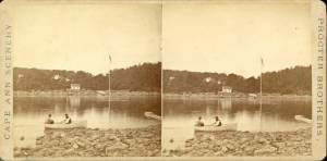
A view of a Cove on the western side of Gloucester Harbor, with the landing at Brookbank. Houses are seen in the woods back. A boat with two men is in the foreground.
Also filed under: Brookbank » // Fresh Water Cove » // Historic Photographs »
Courtesy American Antiquarian Society, Worcester, Mass. (CL.F9116.011.1854 CL.F9116.011.1854)
Also filed under: Oak Hall »
Courtesy American Antiquarian Society, Worcester, Mass. (CL.F9116.011.1854)
Also filed under: Oak Hall »
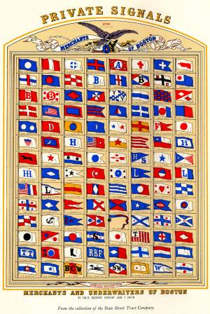
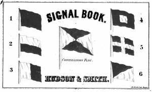
The use of signal flags, for ship-to-ship communication, generally preceded land-based chains of maritime semaphore stations, the latter using flags or rotating arms, until the advent of the electric or magnetic telegraph.
Until the end of the Napoleonic wars, merchant ships generally sailed in convoy as ordered by the escorting warship(s) using a few simple flags. Peace brought independent voyaging, the end of the convoy system, and the realization by various authorities that merchant vessels now needed their own separate means of signaling to each other. This resulted in a handful of rival codes, each with its individual flags and syntax. In general, they each had a section enabling ship identification and also a "vocabulary" section for transmitting selected messages. It was not until 1857 that a common Commercial Code became available for international use, only gradually replacing the earlier ones. All existed side by side for a decade or two.
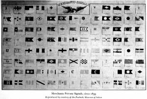
Signal systems for American ships were originally intended to identify a vessel by name and owner; only later were more advanced systems developed to convey messages. Most basic were private signals, or "house flags", each of a different design or pattern, identifying the vessel's owner; identification charts were local and poorly distributed, limiting their usefulness. A secondary signal, a flag or large pennant bearing the vessel's name, was sometimes flown by larger ships, but pictorial records of them are uncommon. These private signal flags usually flew from the foremasthead or main masthead if a three master ship. Pilot boats had their own identifying flags, blue and white as seen in Spitfire Entering Boston Harbor, n.d. (inv. 536). Small vessels, such as schooners, often had a "tell-tale" pennant, an often-unmarked and often red flag, that was used to determine wind direction.
A numerical code flag system, identifying vessels by the code numbers, was introduced by Captain Frederick Marryat R.N. in 1817 for English vessels. American vessels soon adopted this system. Elford's "marine telegraphic system" was the first American equivalent to the Marryat code flags, first issued in 1823, and with changes, remaining in use until the late 1850s. Most of the signal flags on vessels depicted by Lane use Elford's; Brig "Antelope" in Boston Harbor, 1863 (inv. 43) is a noteworthy example of his depiction of Marryat's. The Elford's Code was popular in America on account of its simplicity and only required six blue and white flags. Eventually these changed to red and white, although it is unclear exactly when this happened. Instructions and a key ot the Elford's Code's use are included in successive editions of the Boston Harbor Signal Book.
Whereas the other codes employ at least ten flags of diverse shapes and colours, there are only six Elford flags in total, representing the numbers one to six. All are uniformly rectangular and monochrome in colour (either blue and white or red and white—or even black and white as in an early photograph). Selected from these six flags each individual vessel is allotted a combination of four flags to be prominently displayed as a vertical hoist. Reading from above down these convey its "designated number." Armed with this number and the type of vessel (e.g. ship, bark, brig, schooner /or steamer) the subject can be uniquely identified by reference to a copy of the Boston Harbor Signal Book for the appropriate year.
– A. Sam Davidson
As reproduced in Yankee Sailing Ship Cards by Allan Forbes and Ralph M. Eastman (Boston: State Street Trust Company, 1948).
Also filed under: "Eastern Star" (Bark) » // Forbes, Robert Bennet »
Harvard Depository: Widener (NAV 578.57)
For digitized version, click here.
Also filed under: Boston Harbor »
Boston: Eastburn's Press
New York Public Library
Complete book is included in Google Books, click here.
In The American Neptune 3, no. 3 (July 1943): 205–21.
Peabody Essex Museum
Descriptions of Marryat, Elford, Rogers, and commercial code signal systems, and private signals. Includes illustrations of flag systems with color keys.