An online project under the direction of the CAPE ANN MUSEUM
Catalogue Entry
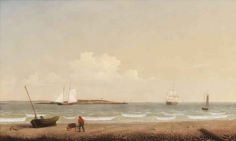
The entrance to Gloucester’s Inner Harbor is marked on the south by Ten Pound Island. Vessels round the island from the Outer Harbor and sail between Rocky Neck and Fort Point into the narrow confines of the Inner Harbor. In summer, prevailing southwesterly winds blow down the Outer Harbor, setting up a downwind chop onto the outer arm of Fort Point and Pavilion Beach.
These conditions make for a very fast downwind sail into the harbor. In the 1850s, any vessel powered only by the wind needed to drop its sails and reduce its speed very quickly in order to make a wharf or a mooring amidst the several hundred vessels crowded within the port.
Lane did numerous paintings of the harbor entrance from either Pavilion Beach or farther out on Fort Point. It was easily accessible to him, and there was always action as sails were hoisted or dropped on the great variety of vessels that were preparing to enter or leave the harbor. In this painting, a lovely schooner has just rounded the island under reduced sail, and the full-rigged ship farther out is dropping sail so as to slow down as it enters the harbor. It is a hazy summer afternoon with a strong southwesterly, onshore breeze. The men on the beach are messing about with their beached yawl boat. One pushes a wheelbarrow with a barrel on it, possibly to off-load the fish they have just caught.
Ten Pound Island from Pavilion Beach has been thought to date from the 1850s, but a close examination of the horizon line of Eastern Point just to the left of Ten Pound Island shows the bulwarks and flagpole of the Civil War fort that was built on Eastern Point in the early 1860s (see enlargement below). A later date also makes sense stylistically, as Lane has markedly reduced the number of elements and simplified the composition, as was typical of his late-period paintings.
The light is subtly rendered; a hazy ochre atmosphere and diffused light pervade the scene. At the top of the canvas, the overall golden-ochre tonality of the sky transitions left to right from a soft blue to a pinkish violet. The cumulus cloud formation building in the sky echoes the placement of Ten Pound Island and reinforces the highlights from the afternoon sun on the rocks. The beach is a mosaic of small stones; a single log on the right leads the eye out to the island and back to the yawl boat on the left.
Further evidence of a date in the 1860s is the somewhat naïve, repetitive pattern of the breaking waves on the beach, which show stylistic evidence of Mary Mellen’s hand. These distinctive wave patterns show up in a number of Lane paintings of this late period and may indicate a collaborative effort by Lane, either to increase his output or to provide a real-life working experience for his student.
– Sam Holdsworth
- Subject Types
: - Landscape Types
: - Beach »
- Vessel Types
: - Cape Ann Locales
: - Objects
: - Building Types
:
Historical Materials

5' 11" l. x 28" h. x 23" w. Wheel 20" d.
19th–early 20th century
Cape Ann Museum. Gift of the Gloucester Fishermen's Museum (2542)
Used to move salt fish in a flake yard. Barrows of this type were commonly used to carry a wide variety of materials around the waterfront.
Filed under: Drying Fish » // Objects »
Eastern Point is the long promontory that defines the eastern limit of Gloucester Harbor. In Lane's day it was wild and uninhabited but was also a strategic landmark. A Civil War fort was built there in 1863. Lane painted his seminal series of Brace's Cove and Brace's Rock from a vantage point on the eastern side.
The area was made safer for navigation by the construction of a new lighthouse in 1831 and the breakwater known as the Dog Bar. First proposed in 1866 in order to reduce turbulence in the waters of the outer harbor during heavy weather, it was not until 1894 that work on its construction began. Progress was slow, and although an extraordinary number of shipwrecks and groundings in 1898 sped it up somewhat, the breakwater was not completed until 1905.
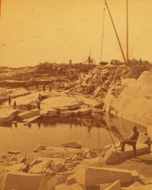
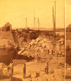
c.1880 Stereograph card Cape Ann Museum Library & Archive
This view shows a wood derrick for hoisting granite blocks.
Also filed under: Granite Quarrying / Shipping » // Historic Photographs »
Glass plate negative from Benham Collection
Cape Ann Museum Library & Archive
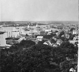
View of Gloucester Harbor from Friend Street Wharves, Five Pound Island segment at far left, Rocky Neck, Eastern Point and Ten Pound Island in background.
Also filed under: Five Pound Island » // Gloucester – City Views »

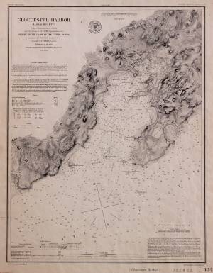
Engraving of 1819 survey taken from American Coast Pilot 14th edition
9 1/2 x 8 in.
Cape Ann Museum Library & Archive
D32 FF5
Also filed under: Dolliver's Neck » // Maps » // Norman's Woe » // Ten Pound Island »

c.1870 Stereograph card Procter Brothers, Publisher Cape Ann Museum Library & Archive
View from Civil War fort on Eastern Point.
Also filed under: Gloucester Harbor, Outer » // Historic Photographs »
c.1880 Stereograph card Cape Ann Museum Library & Archive
This view shows a wood derrick for hoisting granite blocks.
Also filed under: Granite Quarrying / Shipping » // Historic Photographs »
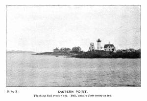
Plate from The Illustrated Coast Pilot with Sailing Directions: The Coast of New England from New York to Eastport, Maine including Bays and Harbors, published by N. L. Stebbins,1896.
Also filed under: Gloucester, Mass. – Eastern Point Light »
Stereograph card
Published by Frank Rowell
Cape Ann Museum Library & Archive
Also filed under: Gloucester, Mass. – Eastern Point Light »

John Heywood Photo for Hervey Friend
Cape Ann Museum Library & Archive (2013.068)
Schooners anchored on the Pancake Ground, taken from from Wonson's Cove, easterly side of the Rocky Neck causeway. Eastern Point Fort and garrison in background to far left.
Also filed under: Gloucester Harbor, Outer »
Gloucester Outer Harbor served as a staging area for deep draft or heavily laden vessels waiting to come into the wharves in the shallow Old Harbor at high tide, or waiting to discharge cargo into smaller vessels. While Lane's paintings typically show one or two vessels in the harbor, works by other artists from the period, as well as contemporary descriptions, demonstrate that the harbor was usually crowded with vessels, especially in bad weather. The Outer Harbor could accommodate as many as three hundred vessels when they needed to shelter during a storm.
There were two deep spots where they could wait, the "Deep Hole" between Ten Pound Island and the Fort; and the "Pancake Grounds" between Ten Pound Island and Eastern Point. The "Pancake Grounds" also served as a quarantine area for ships arriving from foreign ports. "Deep Hole" was named for the (relatively) deep water between Rocky Neck and Fort Point to the Outer Harbor. Deeply loaded vessels had to anchor there for “lightering” (partial unloading by boats called “lighters”) prior to final unloading at wharfside. "Deep Hole" was 20–25 feet deep at low tide, when Harbor Cove was only 1–6 feet deep with bare ground around some wharves. "Deep Hole" is where you see ships anchored in Gloucester Harbor from Rocky Neck, 1844 (inv. 14), The Old Fort and Ten Pound Island, Gloucester, 1850s (inv. 30), , Gloucester Inner Harbor, 1850 (inv. 240), The Fort and Ten Pound Island, Gloucester, Massachusetts, 1847 (inv. 271), and Gloucester Harbor, 1848 (inv. 335) (which is coming to anchor).
The term "Deep Hole" is apparently a post-Bellum term. Prior to that, it was known as "The Stream" and, as later, served as anchorage where deeply loaded vessels could be lightered prior to docking in Harbor Cove. Alfred Mansfield Brooks in his book Gloucester Recollected uses this term on page 53. After the Civil War, merchant shipping in Gloucester was dominated by salt ships and later coal carriers, bringing a whole new culture to the harbor, and with it new names for old places.
John Heywood Photo for Hervey Friend
Cape Ann Museum Library & Archive (2013.068)
Schooners anchored on the Pancake Ground, taken from from Wonson's Cove, easterly side of the Rocky Neck causeway. Eastern Point Fort and garrison in background to far left.
Also filed under: Eastern Point »

c.1870 Stereograph card Procter Brothers, Publisher Cape Ann Museum Library & Archive
"Gloucester Harbor from Rocky Neck, Looking Southwest. This gives a portion of the Harbor lying between Ten Pound Island and Eastern Point. At the time of taking this picture the wind was from the northeast, and a large fleet of fishing and other vessels were in the harbor. In the range of the picture about one hundred vessels were at anchor. In the small Cove in the foreground quite a number of dories are moored. Eastern Point appears on the left in the background."
Southeast Harbor was known for being a safe harbor.
Also filed under: Historic Photographs » // Rocky Neck » // Schooner (Fishing) » // Small Craft – Wherries, and Dories »

Collection of Erik Ronnberg
View related catalogue entries (2) »
Also filed under: Dolliver's Neck » // Fresh Water Cove » // Gloucester Harbor, Inner / Harbor Cove » // Maps »
c.1870 Stereograph card Procter Brothers, Publisher Cape Ann Museum Library & Archive
View from Civil War fort on Eastern Point.
Also filed under: Eastern Point » // Historic Photographs »


44 x 34 in.
Henry Francis Walling, Map of the Towns of Gloucester and Rockport, Essex Co. Massachusetts. Philadelphia, A. Kollner, 1851
Cape Ann Museum Library & Archive
"Map of the Towns of Gloucester and Rockport, Massachusetts. H.F. Walling, Civil Engineer. John Hanson, Publisher. 1851. Population of Gloucester in 1850: 7,805. Population of Rockport in 1850: 3,213."
Also filed under: Annisquam River » // Brookbank » // Dolliver's Neck » // Fresh Water Cove » // Maps » // Norman's Woe » // Stage Rocks / Stage Fort / Stage Head » // Steepbank » // West Gloucester – Little River » // Western Shore »
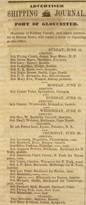
Newsprint
Cape Ann Advertiser
Cape Ann Museum Library & Archive
Notice in the Cape Ann Advertiser announcing arrival of ships into the port of Gloucester, with details of their cargo.
Also filed under: Newspaper / Journal Articles » // Trade Routes and Statistics »
Newspaper
"Lane's studio seldom presents so many attractions to visitors as at the present time. With unwonted rapidity his easel has turned off pictures in answer to the numerous orders which have poured in from all quarters."
Also filed under: Chronology » // Newspaper / Journal Articles » // Studio Descriptions »
Electrotype impression
Collection of Erik Ronnberg
Also filed under: Gloucester Harbor, Inner / Harbor Cove » // Maps »

c.1870 Stereograph card Procter Brothers, Publisher Cape Ann Museum Library & Archive
Also filed under: Historic Photographs » // Stage Rocks / Stage Fort / Stage Head »

Pencil and ink on paper
15 x 22 1/8 in.
Cape Ann Museum, Gloucester, Mass., Gift of Mr. Donald K. Usher, in memory of Mrs. Margaret Campbell Usher, 1984 (2401.19)
Also filed under: Beacons / Monuments / Spindles » // Mackerel Fishing »

Watercolor on paper
8 3/4 x 19 3/4 in.
Cape Ann Museum, Gloucester, Mass., Gift of Rev. and Mrs. A. A. Madsen, 1950
Accession # 1468
Fishing schooners in Gloucester's outer harbor, probably riding out bad weather.
Also filed under: Elwell, D. Jerome » // Schooner (Fishing) »
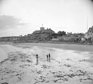
Pavilion Beach is an approximately 1/5 mile long sandy beach that runs along the south side of Commercial Street from Fort Square to the public landing at the easterly end of Western Avenue. The beach faces out over Gloucester Harbor.
Pavilion Beach has long played an important role in the history of Gloucester’s Harbor Village. During Colonial times, the sandy beach was recognized as a crucial barrier between the potentially turbulent waters of Gloucester’s Outer Harbor and the tranquility of Harbor Cove, an inlet which offered a safe area for the construction of wharves and the berthing of vessels. So important was the barrier that during the 1720s town officials awarded a handful of respected merchants a land grant encompassing 80 feet of uplands with the proviso that they promptly build a wharf and maintain it in order to prevent the sea from washing over. During the 1730s, as maritime based commerce slowly took hold around Gloucester Harbor, additional grants were made designed to increase investment in the land and encourage its responsible use. Historian John J. Babson noted that at that same time (c.1730) a group of citizens was enlisted to form a committee… to repair the beach, that the sea might not break over it ‘& spoyl the harbour…” In 1742, funds were appropriated by the General Court of the Commonwealth for the construction of a fortification at the seaward end of Pavilion Beach. The citizens of Gloucester had been asking for protection from possible attacks by sea since the early 1700s. Once commitments were made to the project, the preservation of Pavilion Beach became even more crucial.
For many of Fitz Henry Lane’s generation, here on Cape Ann and afar, Pavilion Beach was synonymous with sightings of the famous Gloucester sea serpent. Reports of a serpent frolicking in Gloucester Harbor were first made in August 1817. So credible were the reports that testimony was formally gathered under oath by the New England Linnaean Society and published in a small tract. The serpent returned in subsequent years generating a flood of publicity which helped jump start Cape Ann’s early summer tourist business in the decades leading up to the Civil War.
– Martha Oaks (April, 2015)
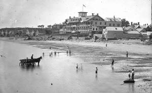
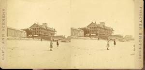
Stereograph card
Cape Ann Museum Library & Archive
Pavilion Hotel and the beach looking west from the Fort, Beach Court and Western Avenue.
Also filed under: Pavilion Hotel »

24 x 38 in.
Gloucester City Archives
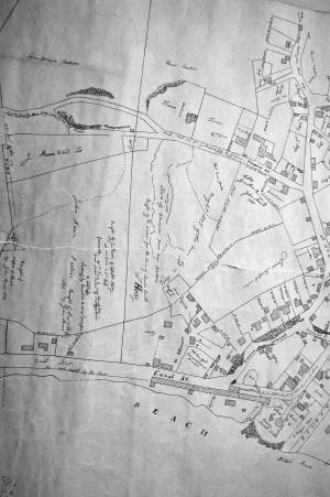
"Drawn on a scale of one hundred feet to an inch. By John Mason 1834–45 from Actual Survey showing every Lott and building then standing on them giving the actual size of the buildings and width of the streets from the Canal to the head of the Harbour & part of Eastern point as farr as Smith's Cove and the Shore of the same with all the wharfs then in use. Gloucester Harbor 1834–35."
This map is especially useful in showing the Fort.
Also filed under: Flake Yard » // Fort (The) and Fort Point » // Maps » // Mason, John » // Town / Public Landings »
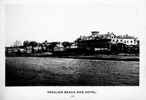
c.1870s Stereograph card Cape Ann Museum Library & Archive
Also filed under: Historic Photographs » // Pavilion Hotel »
1834–35 Lithograph 24 x 38 in. Gloucester City Archives
"Drawn on a scale of one hundred feet to an inch. By John Mason 1834–45 from Actual Survey showing every Lott and building then standing on them giving the actual size of the buildings and width of the streets from the Canal to the head of the Harbour & part of Eastern point as farr as Smith's Cove and the Shore of the same with all the wharfs then in use. Gloucester Harbor 1834–1835."
This section of the map shows the location of the Pavilion Hotel and ropewalk along the beach.
Also filed under: Maps » // Mason, John » // Pavilion Hotel » // Ropewalk » // Windmill »

1834–35 24 x 38 in. Gloucester City Archives
"Drawn on a scale of one hundred feet to an inch. By John Mason 1834–45 from Actual Survey showing every Lott and building then standing on them giving the actual size of the buildings and width of the streets from the Canal to the head of the Harbour & part of Eastern point as farr as Smith's Cove and the Shore of the same with all the wharfs then in use. Gloucester Harbor 1834–35."
This map is especially helpful in showing the wharves of the inner harbor at the foot of Washington Street.
Also filed under: Dale, Eben B. » // Eastern Railroad » // Flake Yard » // Gloucester Harbor, Inner / Harbor Cove » // Hough, Benjamin Kent » // Maps » // Ropewalk » // Sawyer, Samuel » // Town / Public Landings » // Universalist Church (Middle and Church Streets) »
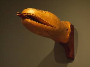
Carved wood with paint and gilt
12 x 22 x 8 in.
Cape Ann Museum. Gift of George W. Woodbury, 1936 (747)
This sea serpent billet head came from the schooner "Diadem" which was built in Essex, Massachusetts, in 1855 and owned by D. Elwell Woodbury and John H. Welsh of Gloucester.
Sea serpents were reportedly sighted here on Cape Ann from colonial times through the mid-nineteenth century. In 1817, more than 50 people, many of them prominent members of the community, reported seeing a serpent in the waters of Gloucester Harbor just off Pavilion Beach. So credible were the reports that the Linnaean Society of New England collected depositions from witnesses and published their findings in a small pamphlet entitled Report of a Committee of the Linnaean Society of New England relative to a Large Marine Animal Supposed to be A Serpent, seen Near Cape Ann, Massachusetts, in August 1817.
Also filed under: Objects » // Vessel Details: Decorations / Ship Carvings »
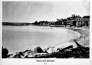
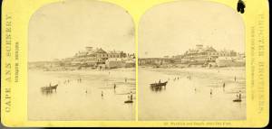
c.1870s Stereograph card Cape Ann Museum Library & Archive
Stereo view of the Pavilion from the southern or sea side.
Also filed under: Historic Photographs » // Pavilion Hotel »
c.1870s Stereograph card Cape Ann Museum Library & Archive
Also filed under: Historic Photographs » // Pavilion Hotel »
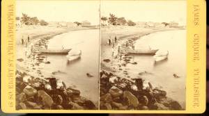
c.1870 Cape Ann Museum Library & Archive
Taken from Fort Point looking west. Ropewalk just to west of hotel.
Also filed under: Historic Photographs » // Pavilion Hotel » // Ropewalk »
c.1900.
Also filed under: Pavilion Hotel »
Ten Pound Island guards the entrance to Gloucester’s Inner Harbor and provides a crucial block to heavy seas running southerly down the Outer Harbor from the open ocean beyond. The rocky island and its welcoming lighthouse is seen, passed, and possibly blessed by every mariner entering the safety of Gloucester’s Inner Harbor after outrunning a storm at sea. Ten Pound Island is situated such that the Inner Harbor is protected from open water on all sides making it one of the safest harbors in all New England.
Legend has it that the island was named for the ten pound sum paid to the Indians for the island, and the smaller Five Pound Island deeper in the Inner Harbor was purchased for that lesser sum. None of it makes much financial sense when the entirety of Cape Ann was purchased for only seven pounds from the Indian Samuel English, grandson of Masshanomett the Sagamore of Agawam in 1700. From approximately 1640 on the island was used to hold rams, and anyone putting female sheep on the island was fined. Gloucester historian Joseph Garland has posited that the name actually came from the number of sheep pens it held, or pounds as they were called, and the smaller Five Pound Island was similarly named.
The island itself is only a few acres of rock and struggling vegetation but is central to the marine life of the harbor as it defines the eastern edge of the deep channel used to turn the corner and enter the Inner Harbor. The first lighthouse was lit there in 1821, and a house was built for the keeper adjacent to the lighthouse.
In the summer of 1880 Winslow Homer boarded with the lighthouse keeper and painted some of his most masterful and evocative watercolor views of the busy harbor life swirling about the island at all times of day. Boys rowing dories, schooners tacking in and out in all weather, pleasure craft drifting in becalmed water, seen together they tell a Gloucester story of light, water and sail much as Lane’s work did only several decades earlier.

Colored lithograph
Cape Ann Museum Library and Archive
Also filed under: Gloucester, Mass. - "Ten Pound Island Light »

Photograph
From The Illustrated Coast Pilot with Sailing Directions. The Coast of New England from New York to Eastport, Maine including Bays and Harbors, N. L. Stebbins, 1891.
Also filed under: Gloucester, Mass. - "Ten Pound Island Light »


Oil on canvas
22 x 36 in.
Cape Ann Museum, Gloucester, Mass., deposited by the Collection of Addison Gilbert Hospital, 1978 (DEP. 201)
Detail of party boat.
Also filed under: Party Boat »
Engraving of 1819 survey taken from American Coast Pilot 14th edition
9 1/2 x 8 in.
Cape Ann Museum Library & Archive
D32 FF5
Also filed under: Dolliver's Neck » // Eastern Point » // Maps » // Norman's Woe »
Newspaper
Gloucester Telegraph
"By the will of the late Fitz H. Lane, Esq., his handsome painting of the Old Fort, Ten Pound Island, etc., now on exhibition at the rooms of the Gloucester Maritime Insurance Co., was given to the town... It will occupy its present position until the town has a suitable place to receive it."

Stereograph card
Cape Ann Museum Library & Archive
View from top of Unitarian Church on Middle Street looking southeast, showing the Fort and Ten Pound Island. Tappan Block and Main Street buildings between Center and Hancock in foreground.
Also filed under: Fort (The) and Fort Point » // Unitarian Church / First Parish Church (Middle Street) »

1860 In John J. Babson, History of the Town Gloucester (Gloucester, MA: Procter Brothers, 1860) Cape Ann Museum Library & Archives, Gloucester, Mass.
See p. 474.
View related catalogue entries (4) »
Also filed under: Babson History of the Town of Gloucester » // Chebacco Boat / Dogbody / Pinky » // Fort (The) and Fort Point » // Gloucester Harbor, Inner / Harbor Cove » // Gloucester, Mass. - "Ten Pound Island Light » // Schooner (Coasting / Lumber / Topsail / Packet / Marsh Hay) »
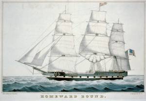
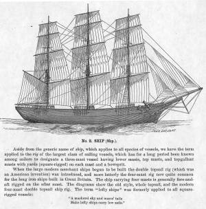
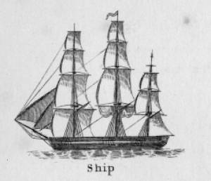
The term "ship," as used by nineteenth-century merchants and seamen, referred to a large three-masted sailing vessel which was square-rigged on all three masts. (1) In that same period, sailing warships of the largest classes were also called ships, or more formally, ships of the line, their size qualifying them to engage the enemy in a line of battle. (2) In the second half of the nineteenth century, as sailing vessels were replaced by engine-powered vessels, the term ship was applied to any large vessel, regardless of propulsion or use. (3)
Ships were often further defined by their specialized uses or modifications, clipper ships and packet ships being the most noted examples. Built for speed, clipper ships were employed in carrying high-value or perishable goods over long distances. (4) Lane painted formal portraits of clipper ships for their owners, as well as generic examples for his port paintings. (5)
Packet ships were designed for carrying capacity which required some sacrifice in speed while still being able to make scheduled passages within a reasonable time frame between regular destinations. In the packet trade with European ports, mail, passengers, and bulk cargos such as cotton, textiles, and farm produce made the eastward passages. Mail, passengers (usually in much larger numbers), and finished wares were the usual cargos for return trips. (6) Lane depicted these vessels in portraits for their owners, and in his port scenes of Boston and New York Harbors.
Ships in specific trades were often identified by their cargos: salt ships which brought salt to Gloucester for curing dried fish; tea clippers in the China Trade; coffee ships in the West Indies and South American trades, and cotton ships bringing cotton to mills in New England or to European ports. Some trades were identified by the special destination of a ship’s regular voyages; hence Gloucester vessels in the trade with Surinam were identified as Surinam ships (or barks, or brigs, depending on their rigs). In Lane’s Gloucester Harbor scenes, there are likely (though not identifiable) examples of Surinam ships, but only the ship "California" in his depiction of the Burnham marine railway in Gloucester (see Three Master on the Gloucester Railways, 1857 (inv. 29)) is so identified. (7)
– Erik Ronnberg
References:
1. R[ichard)] H[enry] Dana, Jr., The Seaman’s Friend, 13th ed. (Boston: Thomas Groom & Co., 1873), p. 121 and Plate IV with captions.
2. A Naval Encyclopaedia (Philadelphia: L. R. Hamersly & Co., 1884), 739, 741.
3. M.H. Parry, et al., Aak to Zumbra: A Dictionary of the World’s Watercraft (Newport News, VA: The Mariners’ Museum, 2000), 536.
4. Howard I. Chapelle, The History of American Sailing Ships (New York: W.W. Norton & Co., 1935), 281–87.
5. Ibid.
6. Howard I. Chapelle, The National Watercraft Collection (Washington, DC: Smithsonian Institution, 1960), 26–30.
7. Alfred Mansfield Brooks, Gloucester Recollected: A Familiar History (Gloucester, MA: Peter Smith, 1974), 67–69.
Photograph
From American Clipper Ships 1833–1858, by Octavius T. Howe and Frederick C. Matthews, vol. 1 (Salem, MA: Marine Research Society, 1926).
Photo caption reads: "'Golden State' 1363 tons, built at New York, in 1852. From a photograph showing her in dock at Quebec in 1884."
Also filed under: "Golden State" (Clipper Ship) »
_sm.jpg)

Oil on canvas
24 x 35 in.
Peabody Essex Museum, Salem, Mass.
Walters' painting depicts the "Nonantum" homeward bound for Boston from Liverpool in 1842. The paddle-steamer is one of the four Clyde-built Britannia-class vessels, of which one is visible crossing in the opposite direction.
View related catalogue entries (2) »
Also filed under: Packet Shipping » // Walters, Samuel »

The Ten Pound Island light was built on a three-and-a-half acre island at the eastern end of Gloucester Harbor. Built as a conical stone tower, the original 20-foot-tall Ten Pound Island Light was first lit in October, 1821 after the Commonwealth of Massachusetts and the Town of Gloucester ceded 1.7 acres to the U.S. Government for the construction of an inner harbor lighthouse to help mariners navigate the harbor. Ten Pound Island light was a popular subject with artists, including Winslow Homer, who boarded with the lighthouse keeper at Ten Pound Island in the summer of 1880. It is frequently featured in Lane's paintings of Gloucester Harbor.
This information has been shared with the Lane project by Jeremy D'Entremont. More information can be found at his website, www.newenglandlighthouses.net or in The Lighthouse Handbook New England. This information has also been summarized from Paul St. Germain's book, Lighthouses and Lifesaving Stations on Cape Ann.

Colored lithograph
Cape Ann Museum Library and Archive
Also filed under: Ten Pound Island »
Photograph
From The Illustrated Coast Pilot with Sailing Directions. The Coast of New England from New York to Eastport, Maine including Bays and Harbors, N. L. Stebbins, 1891.
Also filed under: Ten Pound Island »
