An online project under the direction of the CAPE ANN MUSEUM
Catalogue Entry
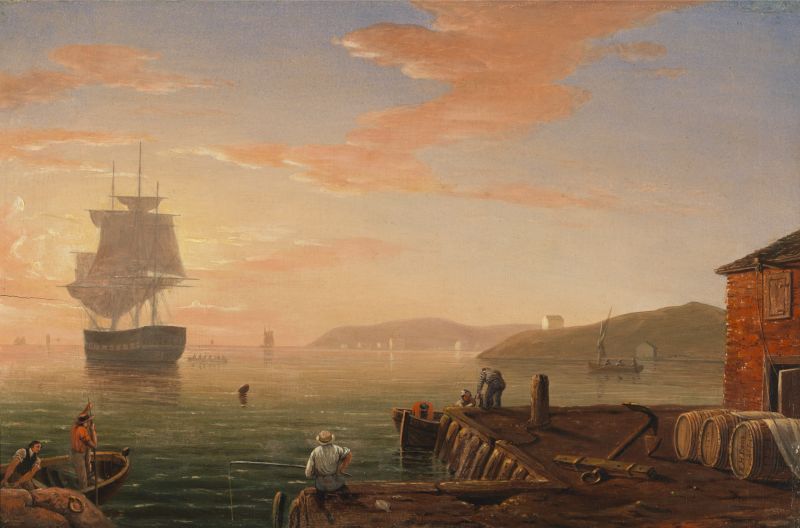
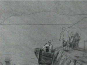
Lane’s small paintings are intimate views of daily life around the waterfront and have an offhand quality. In contrast to the grandeur and formality of many of the larger works, the small paintings capture small moments. In this instance, it is an early morning on the wharves. Nothing much is going on. A few men are messing about in small boats. A fisherman with his pole looks out into the sunrise, while in the distance, a boat rowed by six men approaches a three-masted ship at anchor.
The scene is certainly not Gloucester: at no time of day does the sun sit in that position over the harbor, and the two landforms on the right are unlike anything on Cape Ann. It could be the harbor at Portsmouth, New Hampshire, where a variety of aspects look out to an eastern sea, with hills coming down to the shore in similar configurations. Portsmouth also had some brick buildings on the wharves, unlike Gloucester, and it was a naval base, which might explain the large crew rowing out to what could be a Navy ship.
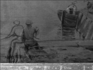
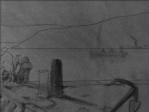
The paint handling is quite casual for Lane, even for 1847, which was relatively early in his painting career. One could imagine this being painted on the spot in one session; more of a sketch than a fully developed work. But note the infrared photographs (below) that show the underdrawing below the paint layers. They reveal a carefully developed composition in which Lane made a number of key adjustments. What may appear to be an offhand work is actually the opposite.
All these changes improve the composition: the fisherman has been moved to the right and the angle of his pole raised; the men bending over on the wharf have been moved, as has the piling sticking up through the wharf behind the men. The fisherman’s pole now points to the men at left; the bow of his boat then leads the eye out on a diagonal into the sunlight that reflects on the harbor in the distance. The rearrangement of the men on the wharf and the piling create more space, opening up the corner of the wharf so the eye can follow its line to the same illuminated distance. The barrels are carefully placed in a row to lead out to the vanishing point on the horizon, reinforcing the strong perspective of the foreground arrangement. Note Lane’s signature and date on the top of the first barrel lying on the wharf.
The charm of this painting is that it is a snapshot of an unremarkable moment with no particular focal point, though bathed in a beautiful light. Yet for all its seeming simplicity, Lane has carefully drawn and then revised the composition in an effort to open up the space and create a cohesive picture. On the Wharves, Gloucester Harbor is an interesting early example of Lane's working methodology in evolution.
– Sam Holdsworth
- Subject Types
: - Seasons / Weather
: - Sunrise »
- Vessel Types
: - Cape Ann Locales
: - Activities of People
: - Objects
:
Historical Materials
Preceded by Annisquam as the earliest permanently settled harbor and Gloucester’s original first parish, Gloucester Harbor did not become a seaport of significance until the end of the 17th century. Its earliest fishing activity was focused on nearby grounds in the Gulf of Maine, few vessels venturing further to the banks off Canada. After 1700, as maritime activity was well-established in fishing, shipbuilding, and coastal trade, the waterfront saw the expansion of flake yards for drying fish and wharves for berthing and outfitting vessels, loading lumber and fish, and receiving trade goods. Shipbuilding was also carried on, using shorelines with straight slopes not suited for wharves.
By 1740, the majority of Cape Ann-owned vessels were berthed in Gloucester Harbor; three years later, Watch House Point (now called Fort Point) was armed and fortified. The fishing fleet continued to grow, numbering over 140 vessels by the time of the Revolution. A customs office was established in 1768, resulting in strong protests over seizures of contraband. Revolution brought hardship to the fishing industry, forcing many vessel owners to resort to privateering.
Independence saw a much-diminished fishing fleet and a severely impoverished seaport. With the Federally-sponsored incentive of the codfish bounties, Gloucester fishermen began to rebuild their fishing fleet. By 1790, trade with Surinam was under way, leading to the building and purchase of merchant vessels, new wharves, and improvements to old wharves in Harbor Cove, which had become Gloucester’s center of maritime activity. In addition to shipyards and sail lofts, two ropewalks furnished cordage for rigging.
The first four decades of the 19th century saw fitful growth in the fishing industry, due to the interruptions of war and financial panics. Few wharves were added to the waterfront in that period, and when new ones were built, their purpose was to serve the growing Surinam Trade. Fishing had come to its low point in the 1840s when the railroad reached Gloucester, opening a huge inland market for the fish it caught. The use of ice to keep fish fresh, combined with new and faster fishing schooners to get it quickly to port, sparked a revival in Gloucester’s fishing industry.
As Gloucester’s fishing industry revived, its growth in the Surinam Trade was hampered by its shallow harbor which made berthing of ever larger ships more difficult. Forced to seek a deeper harbor, merchants reluctantly sent their largest ships to Boston for unloading. Between 1850 and 1860, this process continued until ships and warehouses were relocated and their owners commuted to Boston by rail, leaving their old wharves to the fishing fleet. In 1863, the Surinam trade collapsed.
Gloucester’s fishing fleet grew dramatically in the 1850s for more reasons than ice, railroads, and faster schooners. The technology of catching fish also improved dramatically. Hand-line fishing (two hooks on a line) gave way to dory trawling with many hooks on a very long “trawl line,” while fishing for mackerel with hand-lines was replaced by “purse seining,” setting a 1,000-foot-long net in a circle around a school of mackerel. These dramatic improvements in productivity were expensive but made possible by the fishermen organizing a mutual savings bank to serve their needs and a mutual insurance company to cover their risks. These advantages could not be matched by any other fishing communities in New England or in the Canadian Maritime Provinces, sparking a huge migration of fishermen to Gloucester. These newcomers were welcomed to fill a growing work force while Gloucester’s native work force moved on to other, less dangerous, occupations.
Lane’s depictions of Gloucester’s waterfront best illustrate the period before 1850. After that date, his attention turned more to the Harbor’s outer shores, to nearby communities such as Manchester, to New York, back to Boston, and north to Maine. While his lapse of interest is regrettable, the scenes and activity he missed were becoming popular with photographers while his earlier waterfront views are nowhere else to be found.
–Erik Ronnberg
References:
Dates and happenings were based on (or confirmed by):
Mary Ray and Sarah V. Dunlap, “Gloucester, Massachusetts Historical Time-Line (Gloucester: Gloucester Archives Committee, 2002).
Improvements to Gloucester’s fishing technology, management, and financing are based on:
Wayne O’ Leary, “Maine Sea Fisheries” (Boston: Northeastern University Press, 1996), pp. 166–179 (fishing technology), 235–251 (management and financing), and 235–251 (in-migration to Gloucester).

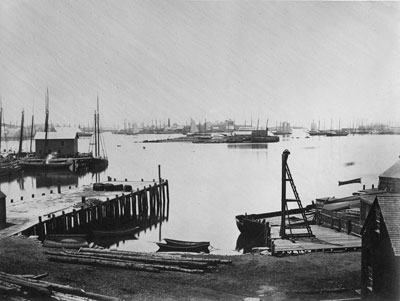
1876 Photograph Cape Ann Museum Library & Archive
Also filed under: Gloucester Harbor, Inner / Harbor Cove » // Historic Photographs » // Schooner (Fishing) »

1876 Photograph Cape Ann Museum Library & Archive
Ignatius Weber's windmill (now defunct) is shown.
Also filed under: Flake Yard » // Fort (The) and Fort Point » // Gloucester Harbor, Inner / Harbor Cove » // Historic Photographs » // Rogers's (George H.) wharves » // Schooner (Fishing) » // Windmill »

44 x 34 in.
John Hanson, Publisher
Cape Ann Museum Library & Archive
"Map of the Towns of Gloucester and Rockport, Massachusetts. H.F. Walling, Civil Engineer. John Hanson, Publisher. 1851. Population of Gloucester in 1850 7,805. Population of Rockport in 1850 3,213."
Also filed under: Fort (The) and Fort Point » // Low (Frederick G.) wharves » // Maps » // Rogers's (George H.) wharves » // Town / Public Landings » // Windmill »
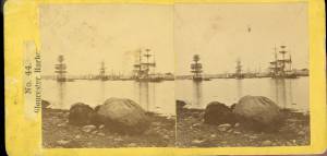
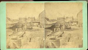
c.1875 Stereograph card Cape Ann Museum Library & Archive
This view of Gloucester's Inner Harbor shows three square-rigged vessels in the salt trade at anchor. The one at left is a (full-rigged) ship; the other two are barks. By the nature of their cargos, they were known as "salt ships" and "salt barks" respectively. Due to their draft (too deep to unload at wharfside) they were partially unloaded at anchor by "lighters" before being brought to the wharves for final unloading.
– Erik Ronnberg
Also filed under: Bark / Barkentine or Demi-Bark » // Historic Photographs » // Salt »
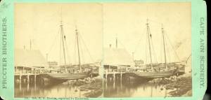
1870s Stereograph card Cape Ann Museum Library & Archive
"Said schooner was captured about the first of September, 1871, by Capt. Torry, of the Dominion Cutter 'Sweepstakes,' for alleged violation of the Fishery Treaty. She was gallantly recaptured from the harbor of Guysboro, N.S., by Capt. Harvey Knowlton., Jr., (one of her owners,) assisted by six brave seamen, on Sunday night, Oct. 8th. The Dominion Government never asked for her return, and the United States Government very readily granted her a new set of papers."
Also filed under: Fishing » // Historic Photographs » // Schooner (Fishing) »
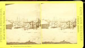
1876 Stereograph card Cape Ann Museum Library & Archive
Stereo view showing Gloucester Harbor after a heavy snowfall
Also filed under: Gloucester Harbor, Inner / Harbor Cove » // Historic Photographs »
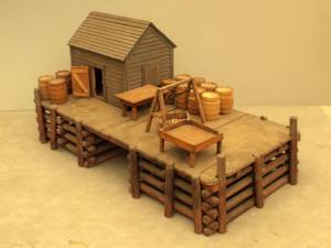
Wood, metal, and paint
20 1/4 x 10 1/4 x 10 1/2 in., scale: 1/2" = 1'
Made for the Columbian Exposition, Chicago, 1892–93
Cape Ann Museum, from Gloucester Chamber of Commerce
The wharf is built up of "cribs", square (sometimes rectangular) frames of logs, resembling a log cabin, but with spaces between crib layers that allow water to flow freely through the structure.Beams are laid over the top crib, on which the "deck" of the wharf is built. Vertical pilings (or "spiles" as locally known) are driven at intervals to serve as fenders where vessels are tied up.
– Erik Ronnberg
Also filed under: Cob / Crib Wharf »
Stereograph card Cape Ann Museum Library & Archive
Also filed under: Fishing » // Historic Photographs »

c.1870 Cape Ann Museum Library & Archive (2013.068)
Schooner fleet anchored in the inner harbor. Looking east from Rocky Neck, Duncan's Point wharves and Lane house (at far left), Sawyer School cupola on Friend Street.
Also filed under: Duncan's Point » // Gloucester Harbor, Inner / Harbor Cove » // Historic Photographs » // Schooner (Fishing) »
The historic New Hampshire port town of Portsmouth has not proven to be the subject of any of Lane's pictures, but there are several for which the topography and buildings suggest a likely identification.
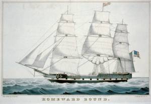
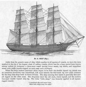
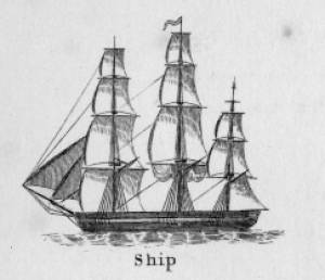
The term "ship," as used by nineteenth-century merchants and seamen, referred to a large three-masted sailing vessel which was square-rigged on all three masts. (1) In that same period, sailing warships of the largest classes were also called ships, or more formally, ships of the line, their size qualifying them to engage the enemy in a line of battle. (2) In the second half of the nineteenth century, as sailing vessels were replaced by engine-powered vessels, the term ship was applied to any large vessel, regardless of propulsion or use. (3)
Ships were often further defined by their specialized uses or modifications, clipper ships and packet ships being the most noted examples. Built for speed, clipper ships were employed in carrying high-value or perishable goods over long distances. (4) Lane painted formal portraits of clipper ships for their owners, as well as generic examples for his port paintings. (5)
Packet ships were designed for carrying capacity which required some sacrifice in speed while still being able to make scheduled passages within a reasonable time frame between regular destinations. In the packet trade with European ports, mail, passengers, and bulk cargos such as cotton, textiles, and farm produce made the eastward passages. Mail, passengers (usually in much larger numbers), and finished wares were the usual cargos for return trips. (6) Lane depicted these vessels in portraits for their owners, and in his port scenes of Boston and New York Harbors.
Ships in specific trades were often identified by their cargos: salt ships which brought salt to Gloucester for curing dried fish; tea clippers in the China Trade; coffee ships in the West Indies and South American trades, and cotton ships bringing cotton to mills in New England or to European ports. Some trades were identified by the special destination of a ship’s regular voyages; hence Gloucester vessels in the trade with Surinam were identified as Surinam ships (or barks, or brigs, depending on their rigs). In Lane’s Gloucester Harbor scenes, there are likely (though not identifiable) examples of Surinam ships, but only the ship "California" in his depiction of the Burnham marine railway in Gloucester (see Three Master on the Gloucester Railways, 1857 (inv. 29)) is so identified. (7)
– Erik Ronnberg
References:
1. R[ichard)] H[enry] Dana, Jr., The Seaman’s Friend, 13th ed. (Boston: Thomas Groom & Co., 1873), p. 121 and Plate IV with captions.
2. A Naval Encyclopaedia (Philadelphia: L. R. Hamersly & Co., 1884), 739, 741.
3. M.H. Parry, et al., Aak to Zumbra: A Dictionary of the World’s Watercraft (Newport News, VA: The Mariners’ Museum, 2000), 536.
4. Howard I. Chapelle, The History of American Sailing Ships (New York: W.W. Norton & Co., 1935), 281–87.
5. Ibid.
6. Howard I. Chapelle, The National Watercraft Collection (Washington, DC: Smithsonian Institution, 1960), 26–30.
7. Alfred Mansfield Brooks, Gloucester Recollected: A Familiar History (Gloucester, MA: Peter Smith, 1974), 67–69.
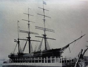
Photograph
From American Clipper Ships 1833–1858, by Octavius T. Howe and Frederick C. Matthews, vol. 1 (Salem, MA: Marine Research Society, 1926).
Photo caption reads: "'Golden State' 1363 tons, built at New York, in 1852. From a photograph showing her in dock at Quebec in 1884."
Also filed under: "Golden State" (Clipper Ship) »
_sm.jpg)

Oil on canvas
24 x 35 in.
Peabody Essex Museum, Salem, Mass.
Walters' painting depicts the "Nonantum" homeward bound for Boston from Liverpool in 1842. The paddle-steamer is one of the four Clyde-built Britannia-class vessels, of which one is visible crossing in the opposite direction.
View related catalogue entries (2) »
Also filed under: Packet Shipping » // Walters, Samuel »

The terms "cob wharf" and "crib wharf" refer to a common form of wharf construction dating from pre-colonial times in Europe to the early nineteenth century in America. Both utilize a rectangular frame of timber called a "crib," which forms the foundation of the timber-and-fill structure built over it.The Hamersly Naval Encyclopaedia defines a crib as "a structure of logs filled with stones, etc., and used as a dam, pier, ice-breaker, etc." A cob is defined as "a breakwater or dock made of piles and timber, and filled in with rocks. The vagueness of these definitions probably explains the interchange of these terms in contemporary descriptions. (1)
In Lane's paintings of Gloucester Harbor, we see what could be both examples of these wharf types on the point of land in Gloucester Harbor, 1847 (inv. 23) at far left. The wharf built up of layers of cribs (like a log cabin) fits the definition of a crib wharf, while the wharf beyond it with vertical pilings enclosing exposed stone would be a cob wharf. Going by this observation, other examples of cob wharves can be found in the depictions of Harbor Cove from the 1840s in The Old Fort and Ten Pound Island, Gloucester, 1850s (inv. 28), The Old Fort and Ten Pound Island, Gloucester, 1850s (inv. 30), and The Fort and Ten Pound Island, Gloucester, Massachusetts, 1847 (inv. 271).
Going by the Hamersly definition of cob wharf, coupled with recent archeological studies of Boston's old waterfront, this constuction was used for both finger piers and bulkhead piers in Gloucester Harbor. Thus, the bukhead piers adjoining and linking the wharves on Fort Point were cob wharves, their stone fill appearing no different from that of the finger piers. (2)
The stone fill used in these wharves was rubble stone: beach stones, field stones, and boulders broken into irregular shapes. Shaped stone blocks of quarried granite do not appear in Lane's depictions of wharves until George H. Rogers began construction of his wharf on Fort Point as noted in Ten Pound Island, Gloucester, 1850s (inv. 17) and Ten Pound Island in Gloucester Harbor, 1864 (inv. 104). The building of this wharf marks a clean break with older wharf construction in Gloucester's Harbor Cove.
– Erik Ronnberg
References::
1. A Naval Encyclopaedia (Philadelphia: L. R. Hamersly & Co., 1884. Reprint: Detroit: Gale Research Co., 1971), 146,182.
2. Nancy S. Seasholes, Breaking Ground: A History of Landmaking in Boston (Cambridge, MA: The MIT Press, 2003), 13–19.
Wood, metal, and paint
20 1/4 x 10 1/4 x 10 1/2 in., scale: 1/2" = 1'
Made for the Columbian Exposition, Chicago, 1892–93
Cape Ann Museum, from Gloucester Chamber of Commerce
The wharf is built up of "cribs", square (sometimes rectangular) frames of logs, resembling a log cabin, but with spaces between crib layers that allow water to flow freely through the structure.Beams are laid over the top crib, on which the "deck" of the wharf is built. Vertical pilings (or "spiles" as locally known) are driven at intervals to serve as fenders where vessels are tied up.
– Erik Ronnberg
Also filed under: Waterfront, Gloucester »
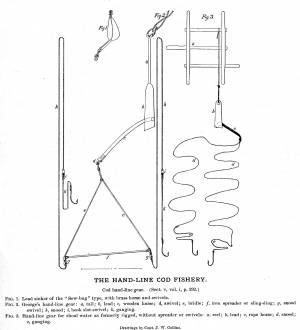
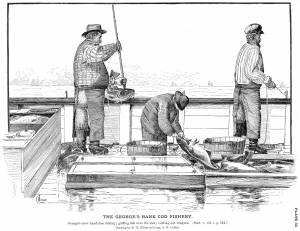
"Hand-lining" was fishing with a single line which had one or sometimes two hooks, as opposed to "trawling," in which a single line had many hooks. Hand-lining was the exclusive American fishing method from colonial times to the mid-19th century, and continued in use, taking second place to dory trawling only after the Civil War. Even then, it persisted into the twentieth century for some offshore fishing grounds, while hand-lining from dories remained a favored method for the shore fisheries.
Hand-line fishing on the offshore banks was done in relatively shallow water (10 to 45 fathoms), often over rocky bottom. This method depended on catching fish at mid-levels as well as on the bottom, hence the lines were relatively short, seldom longer than 75 fathoms. Each fisherman worked two lines, fishing from the schooner's rail. Bait could be salted clams, fresh-caught squid, and even birds.
Hand-lining by American schooners on the Grand Banks declined in the 1830s as they turned to Georges Bank to exploit that neglected resource. In doing so, they turned to a highly modified hand-lining gear using two hooks on a single line. The hooks were on a pair of long gangings (leaders), joined at the sinker and spread apart 12 to 18 inches by a metal rod (or wooden spreader) called a "sling ding." The hand-line itself was much longer - as much as 900 feet, allowing the gear to cover a broad area over a shallow sandy bottom with few obstructions.
On Georges Bank, the schooners anchored where the wind would set the vessels broadside to tidal currents, with the crew fishing from the down-current side. This allowed the lines to be paid out without getting tangled with each other or bunching up astern. The long hand-lines, combined with heavy sinkers and (hopefully) two large cod on the hooks made for strenuous hauling, made all the more so by the tidal current. Georges fishermen were regarded as the strongest in the Cape Ann fisheries.
The wealth of resources and the proximity of Georges Bank was offset by its hazards in heavy weather, as many of Gloucester's widows could testify. Breaking shallows, mountainous waves and winter storms took their toll, but this danger was compounded when numerous vessels anchored within sight of each other. A parted anchor cable could send a vessel crashing into another with the loss of both with their crews.
Steel engraving after drawing in G. Brown Goode, The Fisheries and Fishery Industries of the United States (Washington, DC: Government Printing Office)
8 1/2 x 11 in. (page size)
Cape Ann Museum Library & Archive, Gloucester, Mass.
See pl. 31.
Shows the two basic types of hand-line gear in use in mid-ninteenth century. At left is the Georges gear, developed for fishing on Georges Bank. At right is shoal water gear, as commonly used in the inshore fisheries using dories and other small craft. The spreader, or "sling-ding" was used on this type of gear with the advent of dory hand-lining on offshore grounds.
Also filed under: Cod / Cod Fishing »
Steel engraving after drawing in G. Brown Goode, The Fisheries and Fishery Industries of the United States (Washington, DC: Government Printing Office, 1883)
8 1/2 x 11 in. (page size)
Cape Ann Museum Library & Archive, Gloucester, Mass.
See pl. 32.
Also filed under: Cod / Cod Fishing » // Georges Bank, Mass. »
Model made for marine artist Thomas M. Hoyne
scale: 3/8" = 1'
Thomas M. Hoyne Collection, Mystic Seaport, Conn.
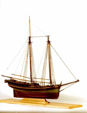
While this model was built to represent a typical Marblehead fishing schooner of the early nineteenth century, it has the basic characteristics of other banks fishing schooners of that region and period: a sharper bow below the waterline and a generally more sea-kindly hull form, a high quarter deck, and a yawl-boat on stern davits.
The simple schooner rig could be fitted with a fore topmast and square topsail for making winter trading voyages to the West Indies. The yawl boat was often put ashore and a "moses boat" shipped on the stern davits for bringing barrels of rum and molasses from a beach to the schooner.
– Erik Ronnberg
References:
Jeffrey Bolster, Black Jacks: African American Seafarers in the Age of Sail (Cambridge, MA: Harvard University Press, 1997).
Howard I. Chapelle, American Small Sailing Craft (New York: W.W. Norton & Co., 1951), 29–31.
Also filed under: Schooner (Fishing) » // Ship Models »