An online project under the direction of the CAPE ANN MUSEUM
Catalogue Entry
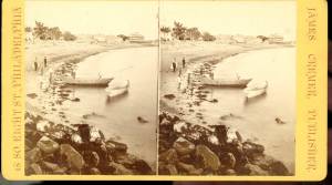
Inscribed verso: S.H. Mansfield
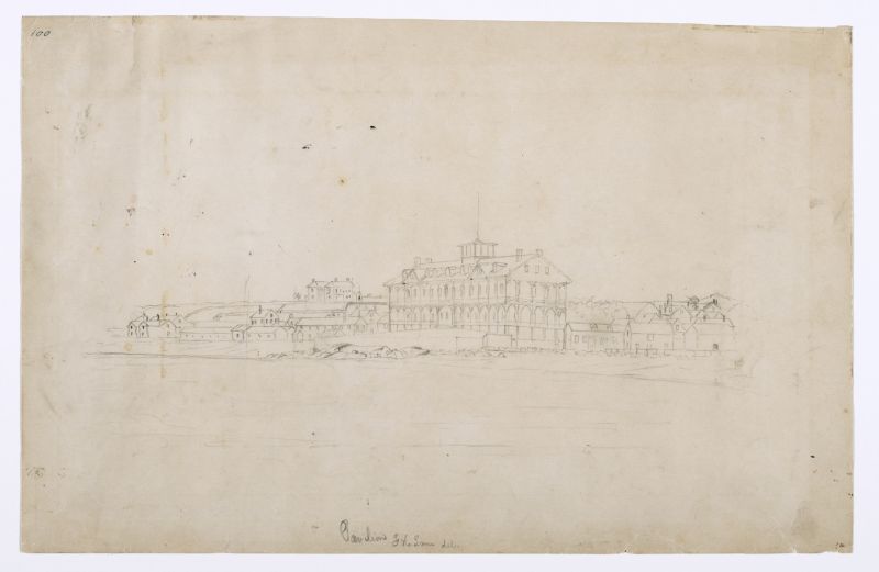
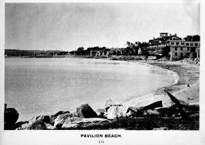
Like Beach and Pavilion, 1850s (inv. 101), this drawing shows not only Sidney Mason's large Pavilion Hotel and the beach in front of it, but the long rope walk to the left and the flake yards to the right. These flake yards can be identified by the tables on which fish (or the "flakes") were spread in the sun to dry.
- Subject Types
: - Landscape Types
: - Beach »
- Cape Ann Locales
: - Activities of People
: - Objects
: - Cod »
- Building Types
: - Flake Yard »
- Hotel »
- Rope Walk »
Historical Materials
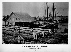
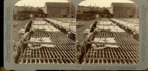
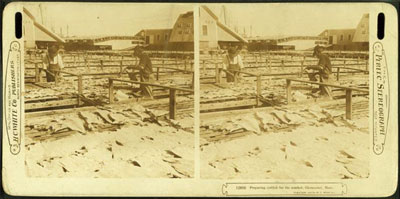
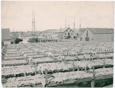
In the days prior mechanical refrigeration, salting and drying were the most common methods of preserving fish. Split cod were spread out on wooden racks, called "fish flakes," to dry. Drying time could take days, depending on weather and temperature. Warm, sunny weather could speed up the drying time, but also "burn" the fish, spoiling its texture and flavor. To prevent this, canvas awnings were stretched over wooden frames built onto the flakes. In wet weather, wooden boxes were placed over the flakes to protect them.
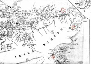
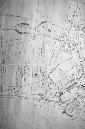
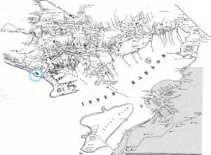
There were several large flake yards in Gloucester in Lane's day. One was situated between Battery Street and the beach, on the long point of land leading to the Fort, and is clearly shown in the 1851 Walling map.
c.1900.
Also filed under: Drying Fish »
Stereograph card Cape Ann Museum Library & Archive
Also filed under: Cod / Cod Fishing » // Drying Fish » // Historic Photographs »

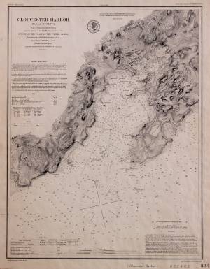
1851 44 x 34 in. Henry Francis Walling, Map of the Towns of Gloucester and Rockport, Essex Co. Massachusetts. Philadelphia, A. Kollner, 1851 Cape Ann Museum Library & Archive
"Map of the Towns of Gloucester and Rockport, Massachusetts. H.F. Walling, Civil Engineer. John Hanson, Printer. 1851. Population of Gloucester in 1850 7,805. Population of Rockport in 1850 3,213."
Also filed under: Baptist Church (Old, First, 1830) (Pleasant Street) » // Burnham Brothers Marine Railway » // Duncan's Point » // Five Pound Island » // Gloucester Harbor, Inner / Harbor Cove » // Harbor Methodist Church (Prospect Street) » // Low (Frederick G.) wharves » // Pavilion Hotel » // Procter Brothers » // Ropewalk » // Vincent's Cove » // Western Shore »

1834–35 24 x 38 in. Gloucester City Archives
"Drawn on a scale of one hundred feet to an inch. By John Mason 1834–45 from Actual Survey showing every Lott and building then standing on them giving the actual size of the buildings and width of the streets from the Canal to the head of the Harbour & part of Eastern point as farr as Smith's Cove and the Shore of the same with all the wharfs then in use. Gloucester Harbor 1834–35."
This map is especially helpful in showing the wharves of the inner harbor at the foot of Washington Street.

24 x 38 in.
Gloucester City Archives
"Drawn on a scale of one hundred feet to an inch. By John Mason 1834–45 from Actual Survey showing every Lott and building then standing on them giving the actual size of the buildings and width of the streets from the Canal to the head of the Harbour & part of Eastern point as farr as Smith's Cove and the Shore of the same with all the wharfs then in use. Gloucester Harbor 1834–35."
This map is especially useful in showing the Fort.
Also filed under: Fort (The) and Fort Point » // Maps » // Mason, John » // Pavilion (Publick) Beach » // Town / Public Landings »
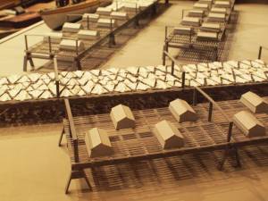
Wood drying racks, metal split salt fish. Scale: ½" = 1' (1:24)
Original diorama components made, 1892; replacements made 1993.
Cape Ann Museum, from Gloucester Chamber of Commerce, 1925 (2014.071)
Fish flakes are wood drying racks for salt codfish, and have been used for this purpose in America since colonial times.
Also filed under: Drying Fish »
44 x 34 in.
John Hanson, Publisher
Cape Ann Museum Library & Archive
"Map of the Towns of Gloucester and Rockport, Massachusetts. H.F. Walling, Civil Engineer. John Hanson, Publisher. 1851. Population of Gloucester in 1850 7,805. Population of Rockport in 1850 3,213."
Also filed under: Maps »

This was Charles F. Hovey's new house when Lane painted Gloucester Harbor from Rocky Neck, 1844 (inv. 14), the hilltop house on the horizon at the far left of the canvas, above the Fort. It is identified as the C.F. Hovey house on the 1851 Walling map and stood high above the outer Harbor, overlooking Gloucester's waterfront. The house that Charles Hovey built has been greatly altered by several owners over the years, but still commands an impressive view of the surrounding sea and land.
The brothers Charles Fox Hovey and George Otis Hovey, sons of Darius and Sarah, were born in Brookfield, Massachusetts. They first appeared in the Gloucester Assessor's Valuations in 1846, when Charles had a house, barn and land worth the substantial sum of $3,000, and George had land and an unfinished house worth $1,000, the beginnings of a vast estate on Dolliver’s Neck, Fresh Water Cove. The brothers enrolled in the Gloucester militia in 1847.
By 1851, both Charles and George lived in Boston, although they continued to own and pay taxes on their Gloucester houses. Charles was an abolitionist of note and a supporter of the women's rights convention. Charles F. Hovey died in Boston on April 28, 1859 of rheumatic gout. The posthumous $50,000 Hovey Fund was managed and allocated by the abolitionist and reformer, Wendell Phillips. George was a merchant and died in Gloucester on July 18, 1877.
Current address: 6 Hovey Street.
– Sarah Dunlap (January, 2014)
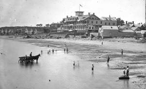
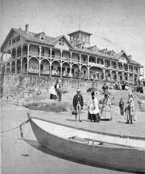
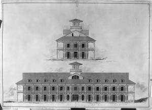
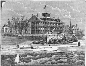
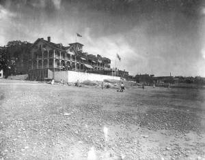
The Pavilion, built in 1849 for Sidney Mason, was Gloucester's first summer resort hotel. Mason was a patron of Lane, and he commissioned him to paint three views of scenes of his mercantile successes: New York Harbor, San Juan [Saint John] Harbor, and Gloucester Harbor, 1852 (inv. 38), in which the hotel, with all its porches, towers and tracery, is a prominent feature. Mason himself helped the architect S. Charles Bugbee design the building, that was then constructed by White and Winchester. A grist windmill, originally owned by Ignatius Webber and then by Sidney Mason's father, John Mason, had stood on the hill since 1814, but, in preparation for the Pavilion Hotel, was moved to the inner-harbor side of the old Fort and eventually burned in 1877. Both the windmill and the Fort can be seen in several Lane harbor paintings and drawings.
Sidney Mason lived in New York City at this time but was closely connected to his home town of Gloucester and owned another, traveler's hotel, the Gloucester House. But the Pavilion brought in an entirely new and different type of visitor to the fishing and trading town of Gloucester. The railroad from Boston had reached Salem in 1839 and Gloucester in November 1847. This not only led to Lane's return to Gloucester after his fifteen year residence in Boston, it also facilitated an influx of summer people. Before this time, a combination of stagecoaches, ferries, steamers and trains was needed to make the trip. Now, the wealthy from New York and Philadelphia could travel easily to Gloucester, as well as to other North Shore communities.
The hotel was not isolated from the business of the town. Next door to the west was one of the several long ropewalks in town. It was built by Ignatius Webber in 1803 and produced many of the miles of hemp rope and twine needed in the maritime trading and fishing trades. To the east, along the beach, were flake yards, where acres of split cod and other fish were laid out to dry in the sun. Lane did not include these in his painting. Nor is there any sign of tension between the tourist hotel and the local inhabitants and industries.
The Pavilion Hotel offered spectacular views and walks, both coastal and inland, and bathing was available all along the public beach that stretched to the Fort. The hotel itself was advertised as elegant, with luxurious sitting rooms, gas lighting and modern conveniences. Its first years were not entirely successful under the management of Dr. H.T. Haughey, once manager of Delaware's Brandywine Springs. But in 1852, Col. Abijah Peabody, manager of Mason's other hotel, the Gloucester House, took over the Pavilion and it flourished.
The Pavilion Hotel grounds were used during the Civil War as a recruiting office. It became the Surfside Hotel, and burned on Saturday, October 17, 1914. It was soon replaced by the Tavern, and that building still exists although no longer as a hotel and without the elegance and architectural flare of the original Pavilion.
Current address: 28–30 Western Avenue, The Tavern.
– Sarah Dunlap (September, 2013)
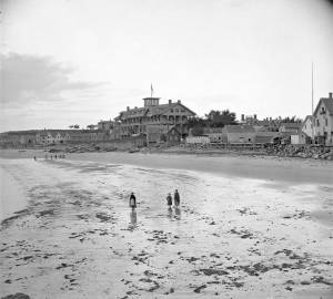
Stereograph card
Cape Ann Museum Library & Archive
Pavilion Hotel and the beach looking west from the Fort, Beach Court and Western Avenue.
Also filed under: Pavilion (Publick) Beach »
1834–35 Lithograph 24 x 38 in. Gloucester City Archives
"Drawn on a scale of one hundred feet to an inch. By John Mason 1834–45 from Actual Survey showing every Lott and building then standing on them giving the actual size of the buildings and width of the streets from the Canal to the head of the Harbour & part of Eastern point as farr as Smith's Cove and the Shore of the same with all the wharfs then in use. Gloucester Harbor 1834–1835."
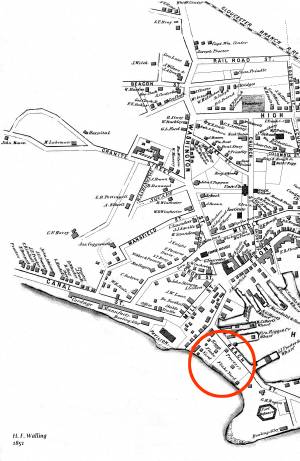
This section of the map shows the location of the Pavilion Hotel and ropewalk along the beach.
Also filed under: Maps » // Mason, John » // Pavilion (Publick) Beach » // Ropewalk » // Windmill »
1851 44 x 34 in. Henry Francis Walling, Map of the Towns of Gloucester and Rockport, Essex Co. Massachusetts. Philadelphia, A. Kollner, 1851 Cape Ann Museum Library & Archive
"Map of the Towns of Gloucester and Rockport, Massachusetts. H.F. Walling, Civil Engineer. John Hanson, Printer. 1851. Population of Gloucester in 1850 7,805. Population of Rockport in 1850 3,213."
Also filed under: Baptist Church (Old, First, 1830) (Pleasant Street) » // Burnham Brothers Marine Railway » // Duncan's Point » // Five Pound Island » // Flake Yard » // Gloucester Harbor, Inner / Harbor Cove » // Harbor Methodist Church (Prospect Street) » // Low (Frederick G.) wharves » // Procter Brothers » // Ropewalk » // Vincent's Cove » // Western Shore »
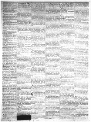
Newspaper
Gloucester Telegraph p. 2 col. 2
Boston Public Library
Accession # G587
"Charlotte Cushman leaves for Europe today in steamship Asia, from New York,– She takes with her two of Lane's finest marine paintings, which she purchased on Monday."
Also filed under: Cushman, Charlotte » // Newspaper / Journal Articles »
1854 Newspaper "Letters on Art. - No. IV"
"In that space [four years] the town has grown greatly . . . a great ugly, yellow "Pavilion" suns itself on the rocks . . . I said there are only two stone buildings in this town of Gloucester: one is "the Bank," the other belongs to Mr. F. H. Lane, whose name ought to be known from Maine to Georgia as the best marine painter in the country.
If Mr. Lane is not as well known as he ought to be, he has at least no reason to complain of neglect or want of appreciation. He has been painting only fifteen years, and his pictures are in great demand; hitherto chiefly among sea-faring men, but now winning way in other circles. In former times I used to be often in Mr. Lane's painting-room, and it was with real pleasure that I found my way to his new house, built from his own design, of native granite, as I mentioned, handsome, peculiar, stable, and commanding a wide sweep of land and ocean from its ample windows. The house is the best that has been built in Gloucester for fifty years. . .
Mr. Lane has put few pictures in his studio at present; for he is very industrious, and sends his canvases off as fast as they are filled. If you were to meet him in the street, you would hardly take him for an artist. A man apparently of forty years, walking with difficulty, supported by crutches, hard-handed, browned by the sun and exposure, with a nose indicating less the artist sensibility than the artist resolution . . .
His early pictures had something in them too hard and practical to permit enthusiastic admiration; the water was salt, the ships sailed, the waves moved, but it was the sea before the Spirit of God moved upon the face of the deep.
His pictures early delighted sailors by their perfect truth. Lane knows the name and place of every rope on a vessel; he knows the construction, the anatomy, the expression – and to a seaman every thing that sails has expression and individuality . . . [Lane] has earned his money thus far mostly by painting "portraits" of vessels for sailors and ship-owners. It is owing to this necessity, perhaps, that he has fallen into the fault of too great literalness of treatment, which I have mentioned as characterizing some of his earlier works; but with the rapid advance he has made in the past four years, there is no longer any fear that he is incapable of treating a subject with genuine imagination . . .
He has indulged in no tricks and no vagaries; he has slighted nothing, despised nothing. If I appear to think less of his early pictures than they deserve, it is not because they are carefully even painfully studied, and because no detail has escaped his eye or brush; it is not that he has too much conscience; but simply because I missed in them the creative imagination of the artist. But it may well be a question whether at this day, when slight and untruthful work prevails, when artists will not paint with conscience, and the public does not strenuously demand it, conscience and love are not higher needs than imagination, and whether Mr. Lane's early pictures, the landmarks on his toilsome, earnest journey to his present place, have not a great value of their own. There is not one of them that I have seen, without some valuable passage, showing acute observation and careful, studious execution.
A sea-piece, "Off the coast of Maine, with Desert-Island in the distance," is the finest picture that Mr. Lane has yet painted. The time is sunset after a storm. The dun and purple clouds roll away to the south-west, the sun sinks in a glory of yellow light, flooding the sea with transparent splendor. Far away in the offing, hiding the sun, sails a brig fully rigged . . . I urged Mr. Lane to send this picture to New-York for exhibition . . ."
Also filed under: Newspaper / Journal Articles » // Residences »
Newsprint
Gloucester Telegraph
Cape Ann Museum Library & Archive
At a Sanitary Fair held at the Pavilion "obtained through the favor and generosity of the owner, Mr. SIDNEY MASON, of New York, and to whom many thanks are due." "... hangs a fine picture, the generous gift of our own Artist, Mr. Lane. The Subject is "Coffin's Beach," as seen from the "Loaf." This is the most costly article on sale in the rooms, and is valued at $100. It will be disposed of by tickets $1 each."
Two paintings by Lane, Little Good Harbor Beach and View from the Loaf were on sale at the Fair.
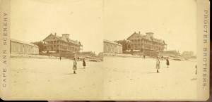
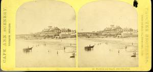
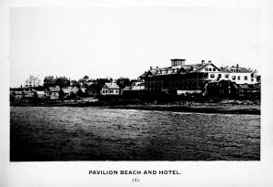
c.1870s Stereograph card Cape Ann Museum Library & Archive
Stereo view of the Pavilion from the southern or sea side.
Also filed under: Historic Photographs » // Pavilion (Publick) Beach »
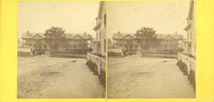
Stereograph card Hervey Friend, Gloucester, Mass., Publisher Cape Ann Museum Library & Archive
Stereo view of the Pavilion Hotel from the street side.
Also filed under: Historic Photographs »
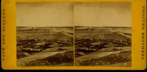
c.1890 Stereograph card Cape Ann Museum Library & Archive
"In the foreground is a clear sheet of water which washes upon the beach beyond. The Pavilion is quite prominent, while upon the rising background can be seen the steeples of the several churchs, the tower of the first Town House, and the Collins School House."
Also filed under: Gloucester – City Views » // Historic Photographs » // Stage Rocks / Stage Fort / Stage Head »
c.1880 Stereograph card Cape Ann Museum Library & Archive
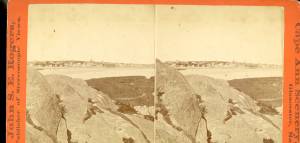
"Bond's Hill is a high eminence on the west side of Gloucester Harbor. The foreground is very rocky and shows a portion of the old road to West Gloucester and Essex, used before the road was built across the marsh, which is to be seen in the center of the picture. Beyond the marsh road is the canal with its dyke. Then the ground rises and dwelling houses appear, till Lookout Hill (or Mount Vernon Street.) can be seen on the left of the background. On the right of the picture is the 'Cut' road, the only carriage entrance into the main part of the town. Beyond it is to be seen 'Crescent Beach,' with the Pavilion and 'old Fort' and a portion of East Gloucester in the background. In the centre of the picture can be seen the unfinished tower of the Town House, and in the distance is the open sea, with Thatcher's Island and its lighthouses just discernible."
Also filed under: Gloucester – City Views » // Historic Photographs »
c.1870s Stereograph card Cape Ann Museum Library & Archive
Also filed under: Historic Photographs » // Pavilion (Publick) Beach »
c.1870s Stereograph card Cape Ann Museum Library & Archive
Also filed under: Historic Photographs » // Pavilion (Publick) Beach »
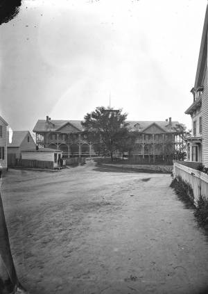
c.1870 Cape Ann Museum Library & Archive
Taken from Fort Point looking west. Ropewalk just to west of hotel.
Also filed under: Historic Photographs » // Pavilion (Publick) Beach » // Ropewalk »
c.1900.
Also filed under: Pavilion (Publick) Beach »
c.1870 Cape Ann Museum Library & Archive
Taken from Fort Point looking west. Ropewalk just to west of hotel.
Also filed under: Historic Photographs » // Pavilion (Publick) Beach » // Pavilion Hotel »
1834–35 Lithograph 24 x 38 in. Gloucester City Archives
"Drawn on a scale of one hundred feet to an inch. By John Mason 1834–45 from Actual Survey showing every Lott and building then standing on them giving the actual size of the buildings and width of the streets from the Canal to the head of the Harbour & part of Eastern point as farr as Smith's Cove and the Shore of the same with all the wharfs then in use. Gloucester Harbor 1834–1835."
This section of the map shows the location of the Pavilion Hotel and ropewalk along the beach.
Also filed under: Maps » // Mason, John » // Pavilion (Publick) Beach » // Pavilion Hotel » // Windmill »
1848 Newsprint D14-7 Cape Ann Museum Library & Archive
A short article entitled "The Cut," and signed "Little Fellow" describes the southwestern part of Gloucester and the beach between the Canal and the Old Fort.
Also filed under: Cut, The (Stacy Blvd.) » // Piper, John J. »
1851 44 x 34 in. Henry Francis Walling, Map of the Towns of Gloucester and Rockport, Essex Co. Massachusetts. Philadelphia, A. Kollner, 1851 Cape Ann Museum Library & Archive
"Map of the Towns of Gloucester and Rockport, Massachusetts. H.F. Walling, Civil Engineer. John Hanson, Printer. 1851. Population of Gloucester in 1850 7,805. Population of Rockport in 1850 3,213."
Also filed under: Baptist Church (Old, First, 1830) (Pleasant Street) » // Burnham Brothers Marine Railway » // Duncan's Point » // Five Pound Island » // Flake Yard » // Gloucester Harbor, Inner / Harbor Cove » // Harbor Methodist Church (Prospect Street) » // Low (Frederick G.) wharves » // Pavilion Hotel » // Procter Brothers » // Vincent's Cove » // Western Shore »


1834–35 Lithograph 24 x 38 in. Gloucester City Archives
"Drawn on a scale of one hundred feet to an inch. By John Mason 1834–45 from Actual Survey showing every Lott and building then standing on them giving the actual size of the buildings and width of the streets from the Canal to the head of the Harbour & part of Eastern point as farr as Smith's Cove and the Shore of the same with all the wharfs then in use. Gloucester Harbor 1834–35."
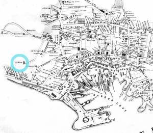
This map shows the location of F. E. Low's wharf and the ropewalk. Duncan's Point, the site where Lane would eventually build his studio, is also marked.
The later notes on the map are believed to be by Mason.
Also filed under: Duncan's Point » // Gloucester Harbor, Inner / Harbor Cove » // Low (Frederick G.) wharves » // Low, Capt. Frederick Gilman » // Maps » // Mason, John » // Residences » // Somes, Capt. John »
1834–35 24 x 38 in. Gloucester City Archives
"Drawn on a scale of one hundred feet to an inch. By John Mason 1834–45 from Actual Survey showing every Lott and building then standing on them giving the actual size of the buildings and width of the streets from the Canal to the head of the Harbour & part of Eastern point as farr as Smith's Cove and the Shore of the same with all the wharfs then in use. Gloucester Harbor 1834–35."
This map is especially helpful in showing the wharves of the inner harbor at the foot of Washington Street.
Gloucester Outer Harbor served as a staging area for deep draft or heavily laden vessels waiting to come into the wharves in the shallow Old Harbor at high tide, or waiting to discharge cargo into smaller vessels. While Lane's paintings typically show one or two vessels in the harbor, works by other artists from the period, as well as contemporary descriptions, demonstrate that the harbor was usually crowded with vessels, especially in bad weather. The Outer Harbor could accommodate as many as three hundred vessels when they needed to shelter during a storm.
There were two deep spots where they could wait, the "Deep Hole" between Ten Pound Island and the Fort; and the "Pancake Grounds" between Ten Pound Island and Eastern Point. The "Pancake Grounds" also served as a quarantine area for ships arriving from foreign ports. "Deep Hole" was named for the (relatively) deep water between Rocky Neck and Fort Point to the Outer Harbor. Deeply loaded vessels had to anchor there for “lightering” (partial unloading by boats called “lighters”) prior to final unloading at wharfside. "Deep Hole" was 20–25 feet deep at low tide, when Harbor Cove was only 1–6 feet deep with bare ground around some wharves. "Deep Hole" is where you see ships anchored in Gloucester Harbor from Rocky Neck, 1844 (inv. 14), The Old Fort and Ten Pound Island, Gloucester, 1850s (inv. 30), , Gloucester Inner Harbor, 1850 (inv. 240), The Fort and Ten Pound Island, Gloucester, Massachusetts, 1847 (inv. 271), and Gloucester Harbor, 1848 (inv. 335) (which is coming to anchor).
The term "Deep Hole" is apparently a post-Bellum term. Prior to that, it was known as "The Stream" and, as later, served as anchorage where deeply loaded vessels could be lightered prior to docking in Harbor Cove. Alfred Mansfield Brooks in his book Gloucester Recollected uses this term on page 53. After the Civil War, merchant shipping in Gloucester was dominated by salt ships and later coal carriers, bringing a whole new culture to the harbor, and with it new names for old places.

John Heywood Photo for Hervey Friend
Cape Ann Museum Library & Archive (2013.068)
Schooners anchored on the Pancake Ground, taken from from Wonson's Cove, easterly side of the Rocky Neck causeway. Eastern Point Fort and garrison in background to far left.
Also filed under: Eastern Point »

c.1870 Stereograph card Procter Brothers, Publisher Cape Ann Museum Library & Archive
"Gloucester Harbor from Rocky Neck, Looking Southwest. This gives a portion of the Harbor lying between Ten Pound Island and Eastern Point. At the time of taking this picture the wind was from the northeast, and a large fleet of fishing and other vessels were in the harbor. In the range of the picture about one hundred vessels were at anchor. In the small Cove in the foreground quite a number of dories are moored. Eastern Point appears on the left in the background."
Southeast Harbor was known for being a safe harbor.
Also filed under: Historic Photographs » // Rocky Neck » // Schooner (Fishing) » // Small Craft – Wherries, and Dories »

Collection of Erik Ronnberg
View related catalogue entries (2) »
Also filed under: Dolliver's Neck » // Fresh Water Cove » // Gloucester Harbor, Inner / Harbor Cove » // Maps »

c.1870 Stereograph card Procter Brothers, Publisher Cape Ann Museum Library & Archive
View from Civil War fort on Eastern Point.
Also filed under: Eastern Point » // Historic Photographs »

44 x 34 in.
Henry Francis Walling, Map of the Towns of Gloucester and Rockport, Essex Co. Massachusetts. Philadelphia, A. Kollner, 1851
Cape Ann Museum Library & Archive
"Map of the Towns of Gloucester and Rockport, Massachusetts. H.F. Walling, Civil Engineer. John Hanson, Publisher. 1851. Population of Gloucester in 1850: 7,805. Population of Rockport in 1850: 3,213."
Also filed under: Annisquam River » // Brookbank » // Dolliver's Neck » // Fresh Water Cove » // Maps » // Norman's Woe » // Stage Rocks / Stage Fort / Stage Head » // Steepbank » // West Gloucester – Little River » // Western Shore »
Newsprint
Cape Ann Advertiser
Cape Ann Museum Library & Archive
Notice in the Cape Ann Advertiser announcing arrival of ships into the port of Gloucester, with details of their cargo.
Also filed under: Newspaper / Journal Articles » // Trade Routes and Statistics »
Newspaper
"Lane's studio seldom presents so many attractions to visitors as at the present time. With unwonted rapidity his easel has turned off pictures in answer to the numerous orders which have poured in from all quarters."
Also filed under: Chronology » // Newspaper / Journal Articles » // Studio Descriptions »
Electrotype impression
Collection of Erik Ronnberg
Also filed under: Gloucester Harbor, Inner / Harbor Cove » // Maps »

c.1870 Stereograph card Procter Brothers, Publisher Cape Ann Museum Library & Archive
Also filed under: Historic Photographs » // Stage Rocks / Stage Fort / Stage Head »

Pencil and ink on paper
15 x 22 1/8 in.
Cape Ann Museum, Gloucester, Mass., Gift of Mr. Donald K. Usher, in memory of Mrs. Margaret Campbell Usher, 1984 (2401.19)
Also filed under: Beacons / Monuments / Spindles » // Mackerel Fishing »

Watercolor on paper
8 3/4 x 19 3/4 in.
Cape Ann Museum, Gloucester, Mass., Gift of Rev. and Mrs. A. A. Madsen, 1950
Accession # 1468
Fishing schooners in Gloucester's outer harbor, probably riding out bad weather.
Also filed under: Elwell, D. Jerome » // Schooner (Fishing) »
Pavilion Beach is an approximately 1/5 mile long sandy beach that runs along the south side of Commercial Street from Fort Square to the public landing at the easterly end of Western Avenue. The beach faces out over Gloucester Harbor.
Pavilion Beach has long played an important role in the history of Gloucester’s Harbor Village. During Colonial times, the sandy beach was recognized as a crucial barrier between the potentially turbulent waters of Gloucester’s Outer Harbor and the tranquility of Harbor Cove, an inlet which offered a safe area for the construction of wharves and the berthing of vessels. So important was the barrier that during the 1720s town officials awarded a handful of respected merchants a land grant encompassing 80 feet of uplands with the proviso that they promptly build a wharf and maintain it in order to prevent the sea from washing over. During the 1730s, as maritime based commerce slowly took hold around Gloucester Harbor, additional grants were made designed to increase investment in the land and encourage its responsible use. Historian John J. Babson noted that at that same time (c.1730) a group of citizens was enlisted to form a committee… to repair the beach, that the sea might not break over it ‘& spoyl the harbour…” In 1742, funds were appropriated by the General Court of the Commonwealth for the construction of a fortification at the seaward end of Pavilion Beach. The citizens of Gloucester had been asking for protection from possible attacks by sea since the early 1700s. Once commitments were made to the project, the preservation of Pavilion Beach became even more crucial.
For many of Fitz Henry Lane’s generation, here on Cape Ann and afar, Pavilion Beach was synonymous with sightings of the famous Gloucester sea serpent. Reports of a serpent frolicking in Gloucester Harbor were first made in August 1817. So credible were the reports that testimony was formally gathered under oath by the New England Linnaean Society and published in a small tract. The serpent returned in subsequent years generating a flood of publicity which helped jump start Cape Ann’s early summer tourist business in the decades leading up to the Civil War.
– Martha Oaks (April, 2015)
Stereograph card
Cape Ann Museum Library & Archive
Pavilion Hotel and the beach looking west from the Fort, Beach Court and Western Avenue.
Also filed under: Pavilion Hotel »
24 x 38 in.
Gloucester City Archives
"Drawn on a scale of one hundred feet to an inch. By John Mason 1834–45 from Actual Survey showing every Lott and building then standing on them giving the actual size of the buildings and width of the streets from the Canal to the head of the Harbour & part of Eastern point as farr as Smith's Cove and the Shore of the same with all the wharfs then in use. Gloucester Harbor 1834–35."
This map is especially useful in showing the Fort.
Also filed under: Flake Yard » // Fort (The) and Fort Point » // Maps » // Mason, John » // Town / Public Landings »
c.1870s Stereograph card Cape Ann Museum Library & Archive
Also filed under: Historic Photographs » // Pavilion Hotel »
1834–35 Lithograph 24 x 38 in. Gloucester City Archives
"Drawn on a scale of one hundred feet to an inch. By John Mason 1834–45 from Actual Survey showing every Lott and building then standing on them giving the actual size of the buildings and width of the streets from the Canal to the head of the Harbour & part of Eastern point as farr as Smith's Cove and the Shore of the same with all the wharfs then in use. Gloucester Harbor 1834–1835."
This section of the map shows the location of the Pavilion Hotel and ropewalk along the beach.
Also filed under: Maps » // Mason, John » // Pavilion Hotel » // Ropewalk » // Windmill »
1834–35 24 x 38 in. Gloucester City Archives
"Drawn on a scale of one hundred feet to an inch. By John Mason 1834–45 from Actual Survey showing every Lott and building then standing on them giving the actual size of the buildings and width of the streets from the Canal to the head of the Harbour & part of Eastern point as farr as Smith's Cove and the Shore of the same with all the wharfs then in use. Gloucester Harbor 1834–35."
This map is especially helpful in showing the wharves of the inner harbor at the foot of Washington Street.
Also filed under: Dale, Eben B. » // Eastern Railroad » // Flake Yard » // Gloucester Harbor, Inner / Harbor Cove » // Hough, Benjamin Kent » // Maps » // Ropewalk » // Sawyer, Samuel » // Town / Public Landings » // Universalist Church (Middle and Church Streets) »
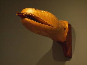
Carved wood with paint and gilt
12 x 22 x 8 in.
Cape Ann Museum. Gift of George W. Woodbury, 1936 (747)
This sea serpent billet head came from the schooner "Diadem" which was built in Essex, Massachusetts, in 1855 and owned by D. Elwell Woodbury and John H. Welsh of Gloucester.
Sea serpents were reportedly sighted here on Cape Ann from colonial times through the mid-nineteenth century. In 1817, more than 50 people, many of them prominent members of the community, reported seeing a serpent in the waters of Gloucester Harbor just off Pavilion Beach. So credible were the reports that the Linnaean Society of New England collected depositions from witnesses and published their findings in a small pamphlet entitled Report of a Committee of the Linnaean Society of New England relative to a Large Marine Animal Supposed to be A Serpent, seen Near Cape Ann, Massachusetts, in August 1817.
Also filed under: Objects » // Vessel Details: Decorations / Ship Carvings »
c.1870s Stereograph card Cape Ann Museum Library & Archive
Stereo view of the Pavilion from the southern or sea side.
Also filed under: Historic Photographs » // Pavilion Hotel »
c.1870s Stereograph card Cape Ann Museum Library & Archive
Also filed under: Historic Photographs » // Pavilion Hotel »
c.1870 Cape Ann Museum Library & Archive
Taken from Fort Point looking west. Ropewalk just to west of hotel.
Also filed under: Historic Photographs » // Pavilion Hotel » // Ropewalk »
c.1900.
Also filed under: Pavilion Hotel »
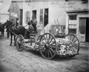
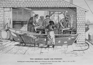
The processing of dried salt cod (the most common form of salt fish) began after the hooked cod came on board and was put in a holding pen on deck until there was a large deck load or the day's fishing was done. At that time, the fish would be split, gutted (the livers were saved, the head removed, and the tongues and cheeks cut out). The split fish were placed in pens in the hold, carefully salted as they were stacked in layers. This initial salting kept them in good condition until they were landed at the fish pier.
After landing, each fish was carefully washed in a dory filled with sea water, removing much of the initial salting. They were then given a second salting, using a finer grade with fewer impurities. Then they were loaded onto a barrow or cart, and wheeled to the flake yard, where they were spread out on wooden racks, called "fish flakes," to dry. Drying time could take days, depending on weather and temperature. Warm, sunny weather could speed up the drying time, but also "burn" the fish, spoiling its texture and flavor. To prevent this, canvas awnings were stretched over wooden frames built onto the flakes.
Rain was also harmful to the fish, which were gathered in compact piles on the flakes and covered with up-turned wooden boxes until dry weather returned. Once dried, the fish were returned to the fish house and stored in a dry room, awaiting skinning, trimming, and packaging for the domestic market.
– Erik Ronnberg
c.1900.
Also filed under: Flake Yard »
Stereograph card Cape Ann Museum Library & Archive
Also filed under: Cod / Cod Fishing » // Flake Yard » // Historic Photographs »
Wood drying racks, metal split salt fish. Scale: ½" = 1' (1:24)
Original diorama components made, 1892; replacements made 1993.
Cape Ann Museum, from Gloucester Chamber of Commerce, 1925 (2014.071)
Fish flakes are wood drying racks for salt codfish, and have been used for this purpose in America since colonial times.
Also filed under: Flake Yard »
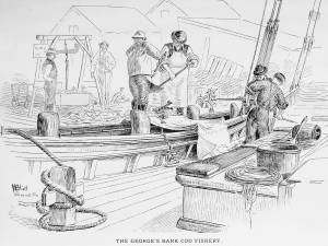
In G. Brown Goode, The Fisheries and Fishery Industries of the United States (Washington, DC: Government Printing Office)
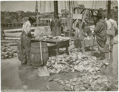
A vessel having returned from the fishing grounds with a fare of split salted cod, is discharging it at a fish pier for re-salting and drying. The fish are tossed from deck to wharf with sharp two-pronged gaffs, and from there to a large scale for weighing. From there, they will be taken to another part of the wharf for washing and re-salting.
– Erik Ronnberg
Also filed under: Cod / Cod Fishing » // Fishing » // Georges Bank, Mass. »
New York Public Library
Also filed under: Cod / Cod Fishing »
In G. Brown Goode The Fisheries and Fishery Industries of the United States (Washington, DC: Government Printing Office)
See pl. 35.
After landing and weighing, the cod are split and washed, a dory filled with water serving as the wash tub. Once thoroughly rinsed of the coarse first salting, the split cod are piled in the wharf shed where they will be re-salted, usually with a finer grade of salt, and stored in bins or large casks until ready for drying on the fish flakes.
– Erik Ronnberg
Also filed under: Cod / Cod Fishing »
Also filed under: Fishing »

5' 11" l. x 28" h. x 23" w. Wheel 20" d.
19th–early 20th century
Cape Ann Museum. Gift of the Gloucester Fishermen's Museum (2542)
Used to move salt fish in a flake yard. Barrows of this type were commonly used to carry a wide variety of materials around the waterfront.
Also filed under: Objects »
The construction of the Gloucester branch of the Eastern Railroad from Salem in 1848 transformed Cape Ann from a sleepy rural area to a bustling metropolis, with summer visitors from Boston and New York arriving daily. The development of the tourist industry was part of a more general growth of tourism up and down the east coast of the United States. Seacoast and mountain areas were served first by stage coaches and then by railroads bringing urban visitors during the summers. Cape Ann was also a day trip for summer residents of places like Beverly and Manchester.
The railroad journey from Boston was not a difficult one. An advertisement listed in the Boston Directory of 1848 reported that there were eleven trains a day for Portsmouth and Salem. It also noted the: "Advantages of a Residence on this Route. No Railroad affords access to so many, so varied, and so splendid sea-side locations, or passes through so many pleasant cities, towns, and vlllages. Its Depots are within a mile or two of the celebrated beaches of Chelsea, Nahant, Swampscot, and Marblehead. A Branch [railroad] skirts the shores of Massachusetts Bay, in the towns of Beverly, Manchester, and Gloucester, opening most magnificent views of the ocean, leading to most retired spots for sea-bathing, and to the most delightful walks and drives in the native forests, that can be found in New England. This shore is rapidly filling up with marine villas and cottages."
By the 1850s Gloucester had three full-size hotels, the Pavilion, the Union House, and the Gloucester House, as well as a number of summer residents, such as Charles Hovey.
Newspaper
"Among the many visitors of the Cape at this delightful season is Champney, the artist, who has been sketching among our quiet coves and breezy headlands."
Also filed under: Champney, Benjamin » // Newspaper / Journal Articles »
Marks: Inscribed upper left (in black ink): 100 [numbering system used by curator A. M. Brooks upon Samuel H. Mansfield's donation of the drawings to the Cape Ann Museum]