An online project under the direction of the CAPE ANN MUSEUM
Catalogue Entry
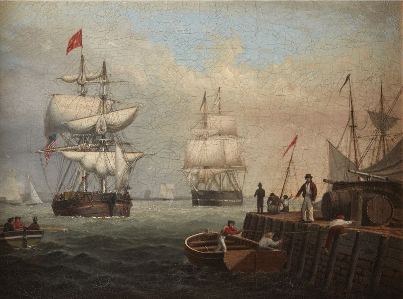
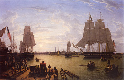
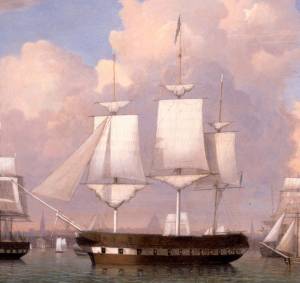
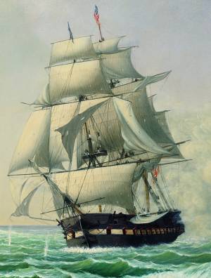
This wonderfully breezy, lively painting depicts an everyday scene off the wharves of Boston Harbor, probably painted in the mid to late 1840’s when Lane was still living and working in Boston. It shows the influence of Robert Salmon in the overall activity and energy of the scene, particularly at the edges where the rowing boat on the left and docked vessels are cut off, giving the feeling of a snapshot of real life rather than a carefully composed composition.
The large rowing boat on the wharf has a sailor scrambling to tie up—are they coming for the smartly attired fellow giving directions from above and for the even more smartly attired top hatted gentleman wearing tails and looking out at the incoming ship? Note the other man in the background rolling a small barrel, perhaps some rum for these could-be owners as they head out on a long voyage?
The name on the bow of the brig is Boston—maybe Lane's way of identifying the setting. The seamanship is impeccable, showing the lowering of squaresails, their clewing-up, and gathering sail with the buntlines in preparation for furling.
The large ship at center appears to be a naval vessel starting to reduce sail in its approach to a naval anchorage. This suggests that the scene is in the northern end of Boston Harbor, and the view is to the southeast or south, making this a mid-afternoon moment. In this painting we see the beginnings of Lane's use of light and atmosphere which is so characteristic of his mature style.
–Sam Holdsworth, Erik Ronnberg
- Subject Types
: - Vessel Types
: - Massachusetts Locales
: - Animals & People
: - Activities of People
: - Rowing »
- Objects
:
Historical Materials
1837 9 x 14 in. Cape Ann Museum Library & Archive
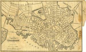
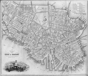
Showing Lane's neighborhood while working in Boston. Lane had studios at the intersection of Washington and State Streets, Summer, Tremont and School Streets.
Also filed under: Lane & Scott's, Lith. – Boston » // Maps » // Professional » // Residences » // Tremont Temple »
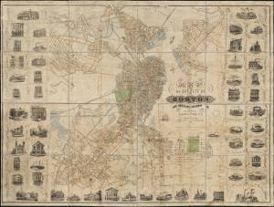
1847 Map insert to Boston Almanac and Directory Cape Ann Museum Library & Archive
Also filed under: Maps » // Residences » // Tremont Temple »
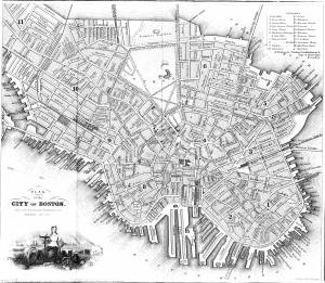
Printed map inside Boston Almanac
Published by B. B. Mussey & Co. and Thomas Groom, Boston
Cape Ann Museum Library & Archive (R910.45 B65 1848)
Map at front of almanac with Tremont Temple highlighted.
Also filed under: Boston Harbor » // Maps » // Tremont Temple »
1852 Boston Boston Public Library: Norman B. Leventhal Map Center Call Number: G3764.B6 1852.M35
Also filed under: Maps » // Residences »
During the years after the war of 1812 and before the Civil War, the port of Boston was a center of American deep-water shipping. Trading with China, India, and the West Indies, which had fueled maritime growth in the early years of the century gave way to re-exporting these goods and foreign trade based on the shoe and textile trades. Although second to New York in terms of shipping tonnage, many of New York's shipbuilders and merchants were Boston based. In addition, ship building continued in Boston. Also, the coastal trade (the domestic trade up and down the coast) was still the most efficient way to transport goods and passengers, and accounts for much of the tonnage and shipping traffic.
Although dwarfed by New York, Boston was an active port in the 1840s and 1850s. Its registered tonnage rose from 149,186 in 1840 to 270,510 in 1850. The harbor was a crowded place. For example, on September 18, 1850, 32 ships, 49 barks, 47 brigs, and 52 schooners were reported at Boston.(1)
In 1849, foreign entries at Boston included 215 ships, 305 barks, 908 brigs, and 52 schooners. Coastwise arrivals included 193 ships, 488 barks, 1087 brigs, 4287 schooners, 89 sloops, and 65 schooners.(2)
(1) W.H. Bunting, p.8.
(2) Ibid.
For more information:
Samuel Eliot Morrison, The Maritime History of Massachusetts, 1783-1860
W.H. Bunting, Portrait of a Port, Boston 1852-1914 Cambridge: The Belknap Press of Harvard University, 1971.
Printed map inside Boston Almanac
Published by B. B. Mussey & Co. and Thomas Groom, Boston
Cape Ann Museum Library & Archive (R910.45 B65 1848)
Map at front of almanac with Tremont Temple highlighted.
Also filed under: Boston City Views » // Maps » // Tremont Temple »
Harvard Depository: Widener (NAV 578.57)
For digitized version, click here.
Also filed under: Signal Systems (Flags & Maritime Codes) »
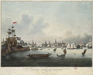
Tinted lithograph with hand coloring
13 7/8 x 22 3/8 in.
Boston Athenaeum
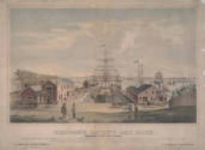
From Sally Pierce and Catharina Slautterback, Boston Lithography, 1825–1880: The Boston Atheneaum Collection (Boston: Athenaeum, 1991): "Tidd drew this print when he was a consulting engineer for Simpson's. He has depicted the clipper ship 'Southern Cross' in the dry dock. Built in 1851, she was known for having sailed from San Francisco to Hong Kong in the record breaking time of thirty-two days. The Bethlehem Ship Building Company eventually took over this location and operated a dry dock there until the mid 1940s."
Also filed under: "Southern Cross" (Clipper Ship) » // M. M. Tidd, Lith. – Boston »
Library of Congress Catalog Number 2004671768
Also filed under: "Britannia" (Cunard Steamship) »
1853
Bostonian Society (1884.0209)
Also filed under: Scott, John W. A. »
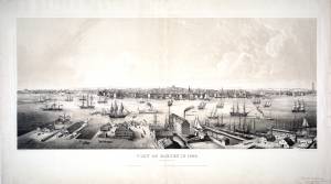
1 print : lithograph, tinted ; image 50.3 x 111.9 cm., 68.7 x 121.2 cm.
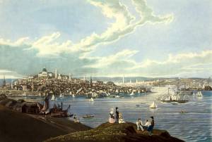
View of the city of Boston from East Boston showing Boston Harbor. The wharves of East Boston can be seen in the foreground.
Number nine of thirty-eight city views published in "Whitefield's Original Views of (North) American Cities (Scenery).
On stone by Charles W. Burton after a drawing by Edwin Whitefield.
Inscribed in brown ink lower right corner of sheet: "Boston Athenaeum from Josiah Quincy. September 28, 1848."
Local Notes:#1848.1.
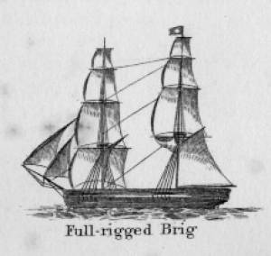
In general, brigs were small to medium size merchant vessels, generally ranging between 80 and 120 feet in hull length. Their hull forms ranged from sharp-ended (for greater speed; see Brig "Antelope" in Boston Harbor, 1863 (inv. 43)) to “kettle-bottom” (a contemporary term for full-ended with wide hull bottom for maximum cargo capacity; see Ships in Ice off Ten Pound Island, Gloucester, 1850s (inv. 44) and Boston Harbor, c.1850 (inv. 48)). The former were widely used in the packet trade (coastwise or transoceanic); the latter were bulk-carriers designed for long passages on regular routes. (1) This rig was favored by Gloucester merchants in the Surinam Trade, which led to vessels so-rigged being referred to by recent historians as Surinam brigs (see Brig "Cadet" in Gloucester Harbor, late 1840s (inv. 13) and Gloucester Harbor at Dusk, c.1852 (inv. 563)). (2)
Brigs are two-masted square-rigged vessels which fall into three categories:
Full-rigged brigs—simply called brigs—were fully square-rigged on both masts. A sub-type—called a snow—had a trysail mast on the aft side of the lower main mast, on which the spanker, with its gaff and boom, was set. (3)
Brigantines were square-rigged on the fore mast, but set only square topsails on the main mast. This type was rarely seen in America in Lane’s time, but was still used for some naval vessels and European merchant vessels. The term is commonly misapplied to hermaphrodite brigs. (4)
Hermaphrodite brigs—more commonly called half-brigs by American seamen and merchants—were square-rigged only on the fore mast, the main mast being rigged with a spanker and a gaff-topsail. Staysails were often set between the fore and main masts, there being no gaff-rigged sail on the fore mast.
– Erik Ronnberg
References:
1. Howard I. Chapelle, The National Watercraft Collection (Washington, DC: Smithsonian Institution, 1960), 64–68.
2. Alfred Mansfield Brooks, Gloucester Recollected: A Familiar History (Gloucester, MA: Peter Smith, 1974), 62–74. A candid and witty view of Gloucester’s Surinam Trade, which employed brigs and barks.
3. R[ichard] H[enry] Dana, Jr., The Seaman's Friend (Boston: Thomas Groom & Co., 1841. 13th ed., 1873), 100 and Plate 4 and captions; and M.H. Parry, et al., Aak to Zumbra: A Dictionary of the World's Watercraft (Newport News, VA: The Mariners’ Museum, 2000), 95.
4. Parry, 95, see Definition 1.
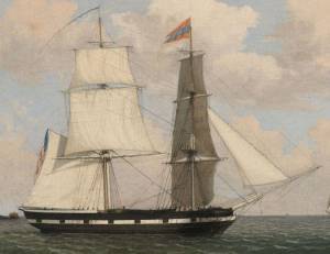
Oil on canvas
17 1/4 x 25 3/4 in.
Cape Ann Museum, Gloucester, Mass., Gift of Isabel Babson Lane, 1946 (1147.a)
Photo: Cape Ann Museum
Detail of brig "Cadet."
Also filed under: "Cadet" (Brig) »
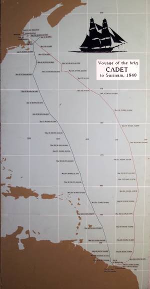
Painting on board
72 x 48 in.
Collection of Erik Ronnberg
Chart showing the voyage of the brig Cadet to Surinam and return, March 10–June 11, 1840.
Also filed under: "Cadet" (Brig) » // Surinam Trade »

Government-owned vessels were mainly concerned with defense of the nation (i.e. the U.S. Navy), the regulation of foreign commerce via enforcement of tariffs and seizure of contraband (i.e. the U.S. Revenue Service), and aids to navigation (i.e. the U.S. Lighthouse Service; coastal life-saving was in the hands of civic organizations).
Naval vessels were classified according to a multitude of duties, which in turn determined hull form and size, propulsion (sail, engine-powered, oars), and numbers and duties of crews.
Revenue service vessels varied from small harbor craft, swift-sailing schooners for coastal and harbor patrols, and large square-rigged (and later engine-powered) ships for off-shore duty. These vessels worked closely with customs houses in seaports with significant foreign commerce.
Oil on canvas
15 3/4 x 23 1/4 in.
Hunter Museum of Art, Chattanooga, Tenn., Museum Purchase (1968.4)
Detail of navel vessel.
Also filed under: "Constitution" (U.S. Frigate) »
Oil on canvas
28 x 42 in.
National Gallery of Art, Washington, D.C., Corcoran Collection (Gift of Mr. and Mrs. Lansdell K. Christie) (2014.136.82)
Detail of naval vessel.
Hand-colored lithograph
Published by N. Currier, New York
Library of Congress catalog number 93514426
Also filed under: Currier (& Ives) – New York »
The yawl boat was a ninteenth-century development of earlier ships' boats built for naval and merchant use. Usually twenty feet long or less, they had round bottoms and square sterns; many had raking stem profiles. Yawl boats built for fishing tended to have greater beam than those built for vessels in the coastal trades. In the hand-line fisheries, where the crew fished from the schooner's rails, a single yawl boat was hung from the stern davits as a life boat or for use in port. Their possible use as lifeboats required greater breadth to provide room for the whole crew. In port, they carried crew, provisions, and gear between schooner and shore. (1)
Lane's most dramatic depictions of fishing schooners' yawl-boats are found in his paintings Gloucester Outer Harbor, from the Cut, 1850s (inv. 109) and /entry:311. Their hull forms follow closely that of Chapelle's lines drawing. (2) Similar examples appear in the foregrounds of Gloucester Harbor, 1852 (inv. 38), Ships in Ice off Ten Pound Island, Gloucester, 1850s (inv. 44), and The Fort and Ten Pound Island, Gloucester, Massachusetts, 1847 (inv. 271). A slightly smaller example is having its bottom seams payed with pitch in the foreground of Gloucester Harbor, 1847 (inv. 23). In Gloucester Inner Harbor, 1850 (inv. 240), a grounded yawl boat gives an excellent view of its seating arrangement, while fishing schooners in the left background have yawl boats hung from their stern davits, or floating astern.
One remarkable drawing, Untitled, n.d. (inv. 219) illustrates both the hull geometry of a yawl boat and Lane's uncanny accuracy in depicting hull form in perspective. No hull construction other than plank seams is shown, leaving pure hull form to be explored, leading in turn to unanswered questions concerning Lane's training to achieve such understanding of naval architecture.
– Erik Ronnberg
References:
1. Howard I. Chapelle, American Small Sailing Craft (New York: W.W. Norton & Co., 1951), 222–23.
2. Ibid., 223.
Oil on canvas
12 1/8 x 19 3/4 in.
Museum of Fine Arts, Boston, Bequest of Martha C. Karolik for the M.and M. Karolik Collection of American Paintings, 1815-1865 (48.447)
A schooner's yawl lies marooned in the ice-bound harbor in this detail.
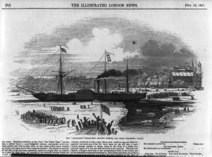
The ensign of the United States refers to the flag of the United States when used as a maritime flag to indentify nationality. As required on entering port, a vessel would fly her own ensign at the stern, but a conventional token of respect to the host country would be to fly the flag of the host country (the United States in Boston Harbor, for example) at the foremast. See The "Britannia" Entering Boston Harbor, 1848 (inv. 49) for an example of a ship doing this. The American ensign often had the stars in the canton arranged in a circle with one large star in the center; an alternative on merchant ensigns was star-shaped constellation. In times of distress a ship would fly the ensign upside down, as can be seen in Wreck of the Roma, 1846 (inv. 250).
The use of flags on vessels is different from the use of flags on land. The importance and history of the flagpole in Fresh Water Cove in Gloucester is still being studied.
The modern meaning of the flag was forged in December 1860, when Major Robert Anderson moved the U.S. garrison from Fort Moultrie to Fort Sumter in Charleston Harbor. Adam Goodheart argues this was the opening move of the American Civil War, and the flag was used throughout northern states to symbolize American nationalism and rejection of secessionism.
Before that day, the flag had served mostly as a military ensign or a convenient marking of American territory, flown from forts, embassies, and ships, and displayed on special occasions like American Independence day. But in the weeks after Major Anderson's surprising stand, it became something different. Suddenly the Stars and Stripes flew—as it does today, and especially as it did after the September 11 attacks in 2001—from houses, from storefronts, from churches; above the village greens and college quads. For the first time American flags were mass-produced rather than individually stitched and even so, manufacturers could not keep up with demand. As the long winter of 1861 turned into spring, that old flag meant something new. The abstraction of the Union cause was transfigured into a physical thing: strips of cloth that millions of people would fight for, and many thousands die for.
– Adam Goodheart, Prologue of 1861: The Civil War Awakening (2011).
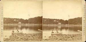
1860s Stereograph card Cape Ann Museum Library & Archive
A view of a Cove on the western side of Gloucester Harbor, with the landing at Brookbank. Houses are seen in the woods back. A boat with two men is in the foreground.
Also filed under: Brookbank » // Fresh Water Cove » // Historic Photographs »
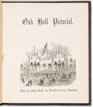
Courtesy American Antiquarian Society, Worcester, Mass. (CL.F9116.011.1854 CL.F9116.011.1854)
Also filed under: Oak Hall »
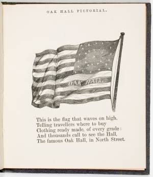
Courtesy American Antiquarian Society, Worcester, Mass. (CL.F9116.011.1854)
Also filed under: Oak Hall »
Labels: Newman Galleries Label