An online project under the direction of the CAPE ANN MUSEUM
Babson House
View related Fitz Henry Lane catalogue entries (5) »
Traditionally known as the Babson-Alling House, this two-and-a-half-story gambrel-roofed structure was constructed in 1740 for Joseph Allen, Jr., a successful merchant and land owner, and his family. It is located at what was once Gloucester’s Town Green, the center of civic and religious life during the Colonial era. The gable end of the house sits parallel to Washington Street and the front façade faces south. By Lane’s time, the house was occupied by the Babson family; the fields surrounding it were given over to haying, gardens, and grazing of cows. Shortly before Nathaniel Babson's death in 1863, ownership of the Babson House was taken over by Maria and Emma's uncle, Gustavus Babson (1820–97). The Babson House is now owned by the Cape Ann Museum.
– Martha Oaks (May, 2015)
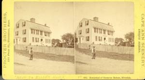
Stereograph card Cape Ann Museum Library & Archive
Stereo view of the house owned by Nathaniel Babson (Emma and Maria). The house was sold to Gustavus shortly before Nathaniel's death.
Also filed under: Babson, Nathaniel » // Historic Photographs »
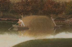
1863 Oil on canvas 22 x 36 in. Cape Ann Museum, Gloucester, Mass., Gift of Roger W. Babson, 1937 (779.02)
Detail showing a flat-bottomed gundalow loaded with marsh hay and being propelled by men with long sweeps.
View related catalogue entries (1) »
Also filed under: Gundalow / Scow » // Salt Marsh Hay / English Hay »
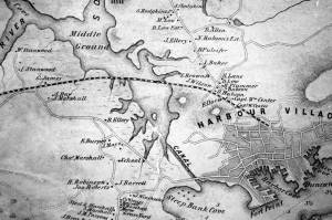
1851 44 x 34 in. Henry Francis Walling, Map of the Towns of Gloucester and Rockport, Essex Co. Massachusetts. Philadelphia, A. Kollner, 1851 Cape Ann Museum Library & Archive
"Map of the Towns of Gloucester and Rockport, Massachusetts. H.F. Walling, Civil Engineer. John Hanson, Publisher. 1851. Population of Gloucester in 1850 7,805. Population of Rockport in 1850 3,213."
Also filed under: Cut, The (Stacy Blvd.) » // Town / Public Landings » // White-Ellery House »
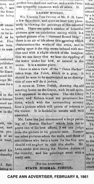
2.8.1861 Newsprint From bound volume owned by publisher Francis Procter Collection of Fred and Stephanie Buck
"We visited the studio of Mr. F.H. Lane a few days since, and spent an hour very pleasantly in viewing the paintings of this talented artist. There are quite a number of beautiful pictures now on exhibition among which is a spirited picture of an 'Outward Bound Ship'; there is an air of life about this painting which characterizes the works of this artist, and in gazing upon it the ship seems imbued with motion and with a slight stretch of the imagination we can fancy that we hear the rippling of the water under her bow, so natural is the scene. It is a master piece.
There is also a view of the 'Outer Harbor' taken from the Point, which is a gem. It should be seen to be appreciated as no description of ours will do it justice.
A scene at Town Parish, showing the old meeting house on the Green, with its tall spire, as it appeared in days agone. The old Ellery house, and Babson House are prominent features, which with the surrounding scenery form a picture which will prove of interest to the visitor. It is faithful to nature and well executed.
Mr. Lane has just commenced a large painting of 'Boston Harbor' which bids fair to prove one of his best efforts, if we can judge from the picture in its present state. Numerous other pictures adorn the walls, and those of our citizens who have a taste for the fine arts should not neglect to visit the studio. Mr. Lane ranks among the Marine Artists of the country, and his paintings meet with a ready sale."
View related catalogue entries (1) »
Also filed under: Newspaper / Journal Articles » // Studio Descriptions »
1823 Cape Ann Museum Library & Archive Grayscale version of color original
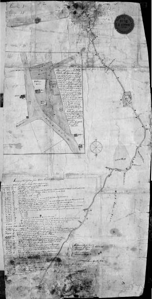
Map of Riverdale from the Mills to the Whittemore House at Middle and Washington Streeets ordered by a committee of selectmen, William Pearce, Samuel Stevens, Daniel H. Rogers with John Mason and Anthony Presson. Map drawn by surveyor William Saville and present to the committee in June, 1823. It contains a enlarged view of The Green, including the Ellery and Babson houses painted by Lane.
Also filed under: Low (David) House » // Maps » // Meetinghouse Green » // Riverdale / Town Parish » // Riverdale Mills »
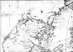
1851 44 x 34 in. Henry Francis Walling, Map of the Towns of Gloucester and Rockport, Essex Co. Massachusetts. Philadelphia, A. Kollner, 1851 Cape Ann Museum Library & Archive
"Map of the Towns of Gloucester and Rockport, Massachusetts. H.F. Walling, Civil Engineer. John Hanson, Publisher. 1851. Population of Gloucester in 1850 7,805. Population of Rockport in 1850 3,213."
View related catalogue entries (1) »
Also filed under: Annisquam River » // Coffin's Beach » // Eastern Railroad » // Gloucester, Mass. – Annisquam Harbor Lighthouse » // Granite Quarrying / Shipping » // Loaf, The » // Low (David) House » // Maps » // Old First Parish / Subsequent Fourth Parish Church (at the Green) » // Riverdale Methodist Church (Washington Street) » // White-Ellery House »
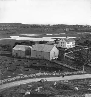
c.1869 Stereograph card Cape Ann Museum Library & Archive
View of the Babson Farm taken from Pole's Hill, showing the old Murray Meeting House (rear section of barn), fields and Mill River. In the background is the skyline of the major buildings at Harbor Village, including the first version of City Hall destroyed by fire in 1869.
Also filed under: Riverdale / Town Parish » // Universalist (Original) Meeting House (Sargent) »

Video tour, Cape Ann Museum, 2022
This short video tour provides an overview of the Babson-Alling House (c. 1740).
This video, along with virtual tours of the White-Ellery House, and the Captain Elias Davis House were generously funded by a grant from MassHumanities.