An online project under the direction of the CAPE ANN MUSEUM
Catalogue Entry

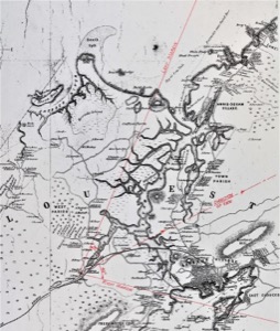
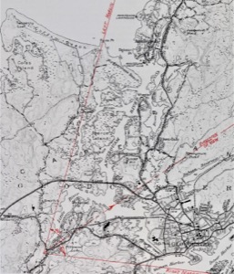
Named for a wrong location (and a then-defunct mill), this scene actually depicts the Bray mill on Mill River in West Gloucester, looking north-easterly to the Annisquam River with Annisquam Village in the distance. Two maps (see below) are necessary to understand the topography and direction of this view. The earlier (H. F. Walling) map omits Rust Island, the dark point of land in left background which faces opposite Ferry Hill in the U.S. Geological Survey map. The latter map also shows more clearly the tidal marshes which are mostly covered by high spring tides, making the Annisquam River appear much wider.
The part of the Mill River in Lane’s painting is on a rapid descent from the high ground which hides the port of Gloucester from view. Note the railroad cut in the hillside at far right, where a steam locomotive is emerging. The road in the right middle ground is Essex Avenue which can still be traveled today, though through much-changed surroundings.
The saw mill at center foreground is identified as owned by D. and J. Bray, members of a large family who mostly lived and worked in West Gloucester. Their ancestry has been traced back to Thomas Bray, a ship carpenter who married Maria Wilson at Gloucester in 1646 — the earliest recorded date of his presence in this area. Further information on the saw mill and its owners has not been found. This was a large family of laborers and skilled workers who were unlikely to spend precious savings on a painting. It therefore seems more likely that this setting inspired Lane to depict it on speculation, or on commission by a client who lived elsewhere but had some appreciation or fond memories of West Gloucester, particularly now that the train line came through, completed just a few years before this painting.
This is one of Lane’s rare early landscapes where he shows his extraordinary skill with the variegated foliage that fills nearly half the painting. The loading in of the logs to be milled, the wagon plodding by on the road, the ducks on the pond, the cow grazing on the roadside all add up to a wonderful genre scene of an ordinary day in the life of the still rural West Gloucester.
– Erik Ronnberg
- Subject Types
: - Landscape Types
: - Cape Ann Locales
: - Animals & People
: - Objects
: - Building Types
: - Mill »
Historical Materials
The construction of the Gloucester branch of the Eastern Railroad from Salem in 1848 transformed Cape Ann from a sleepy rural area to a bustling metropolis, with summer visitors from Boston and New York arriving daily and tons of fish and other goods being shipped back and forth to and from points west. New England Inlet with Self-Portrait, 1848 (inv. 77) shows the train, but it is omitted in two sketches of the area. The 1834–35 Mason map notes that John Mason sold a large area of land to the railroad company in 1845.
Cape Ann Museum Library & Archive
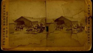
Stereograph card of Eastern Railroad Depot with 9:30 up train, August 11, 1874.
Also filed under: Historic Photographs »

1834–35 24 x 38 in. Gloucester City Archives
"Drawn on a scale of one hundred feet to an inch. By John Mason 1834–45 from Actual Survey showing every Lott and building then standing on them giving the actual size of the buildings and width of the streets from the Canal to the head of the Harbour & part of Eastern point as farr as Smith's Cove and the Shore of the same with all the wharfs then in use. Gloucester Harbor 1834–35."
This map is especially helpful in showing the wharves of the inner harbor at the foot of Washington Street.
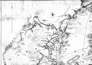
1851 44 x 34 in. Henry Francis Walling, Map of the Towns of Gloucester and Rockport, Essex Co. Massachusetts. Philadelphia, A. Kollner, 1851 Cape Ann Museum Library & Archive
"Map of the Towns of Gloucester and Rockport, Massachusetts. H.F. Walling, Civil Engineer. John Hanson, Publisher. 1851. Population of Gloucester in 1850 7,805. Population of Rockport in 1850 3,213."
Also filed under: Annisquam River » // Babson House » // Coffin's Beach » // Gloucester, Mass. – Annisquam Harbor Lighthouse » // Granite Quarrying / Shipping » // Loaf, The » // Low (David) House » // Maps » // Old First Parish / Subsequent Fourth Parish Church (at the Green) » // Riverdale Methodist Church (Washington Street) » // White-Ellery House »
West Gloucester, or West Parish as it was more commonly called in Lane’s time, is a world apart in many ways. First it is not on Cape Ann, which is actually an island, it is mainland west of the cape, bounded by Essex and Manchester. Its coastline is all either salt marsh or beach if we use Little River as its southern boundary. The ocean is buffered by barrier beaches and salt marshes, and its warmer and calmer water provides a hatchery for a great number of the species of deepwater fish caught out of Gloucester.
Second Parish was the earliest name of this area. It was populated very early, around 1650, for unknown reasons because the area has poor soil for farming, endless granite moraines and limited access to the sea. From inception through 1716 the parish faithful went a long way to worship. They made their way a number of difficult miles overland to Rust Island, then ferried across the Annisquam River to Wolf Hill and walked again to Meetinghouse Green, site of the First Parish church. Finally they built their own meetinghouse in 1716 on the top of the hill on Tompson Street, still visible from a walking trail. This church lasted until 1846, when it was dismantled and moved and a new church built on Essex Ave.
In Lane’s time it was a very quiet area, the only activity being some small farms, a sawmill, a tidal grist mill on Walker Creek and some clamming and marsh haying. Lane came over at least several times, we have a drawing and painting from 1850 of a sunset view of the Chebacco River off Concord Street, then in 1860 several drawings and paintings of Coffin’s Beach and Freeman’s Encampment at the Loaf, a large sand dune behind Coffin’s Beach.
– Sam Holdsworth
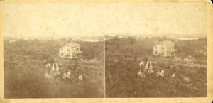
Stereograph card
Cape Ann Museum Library & Archive
Stereo View
Also filed under: Historic Photographs » // Low, Colonel David »

44 x 34 in.
Henry Francis Walling, Map of the Towns of Gloucester and Rockport, Essex Co. Massachusetts. Philadelphia, A. Kollner, 1851
Cape Ann Museum Library & Archive
"Map of the Towns of Gloucester and Rockport, Massachusetts. H.F. Walling, Civil Engineer. John Hanson, Publisher. 1851. Population of Gloucester in 1850: 7,805. Population of Rockport in 1850: 3,213."
Also filed under: Annisquam River » // Brookbank » // Dolliver's Neck » // Fresh Water Cove » // Gloucester Harbor, Outer » // Maps » // Norman's Woe » // Stage Rocks / Stage Fort / Stage Head » // Steepbank » // Western Shore »