Fitz Henry Lane
HISTORICAL ARCHIVE • CATALOGUE RAISONNÉ • EDUCATIONAL RESOURCE
An online project under the direction of the CAPE ANN MUSEUM
An online project under the direction of the CAPE ANN MUSEUM
« previous // next »
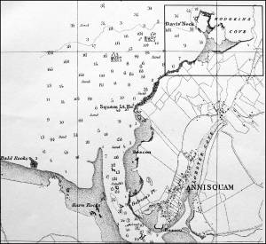
Davis' Neck
View related Fitz Henry Lane catalogue entries (1) »
Davis’ Neck, which lies between Lanesville and Annisquam, marks the western entrance to Hodgkins Cove. Ipswich Bay was a major stop along the Atlantic Flyway for migratory waterfowl, and this part of Cape Ann’s coastline provided rest and nourishment for many species.
chart
Chart of Ipswich Bay with Davis Neck inset
US Coast Survey preliminary chart of Ipswich Bay, 1855
Also filed under: Annisquam River »
« previous // next »
Please note that the information on this and all pages is periodically reviewed and subject to change.
Citation: "Cape Ann Locales." In Fitz Henry Lane Online. Gloucester, MA: Cape Ann Museum. www.fitzhenrylaneonline.org/historical_material/?section=Davis%27+Neck&type=Cape+Ann+Locales (accessed on July 29, 2026).