An online project under the direction of the CAPE ANN MUSEUM
Catalogue Entry
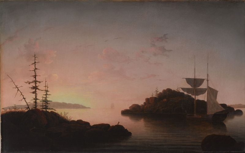
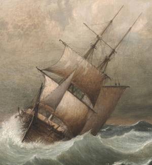
Many of Lane’s paintings of the 1860s, particularly of Maine, are the culminating works of his career. The decade long trend since the early 1850s of simplifying composition, paring down of detail and the primacy of light and atmosphere are all at work in this exquisite painting of 1863.
Lane uses his familiar reverse Z composition, leading the eye into the painting from the lower right center following the water up to the anchored hermaphrodite brig and island. He then turns you left around the island as the reflected light thickens on the sea and then leads the eye right to the horizon. It’s likely a dawn view with the sun rising from the open ocean beyond the islands. While the subject is the dawn light spreading across the sea in all its spectacular gradations, note the two devices with which he enlivens the composition. On the left side he has the dead tree leaning away from the other verticals, creating an energetic diagonal that also leads the eye down to the water where the eye enters the painting. As you follow the dark line of the island on the left towards the center, he has placed a lone heron standing on the rock silhouetted against the glowing water. Every aspect of the scene is at rest, yet there is an expectant energy emanating from the glowing sun reaching across the water but not yet warming the cool shadows behind the islands. The ship becomes just another aspect of nature, sails hanging still and silent, waiting for the day to awaken it.
The locale is not Christmas Cove, which is a cove south of the Penobscot Bay that doesn’t have any islands or configurations that would fit this view. It is rumored to have been titled by a dealer trying to sell the picture to a Christmas Cove summer resident. Penobscot Bay, where Lane cruised extensively on his summer trips, is full of small islands that look like these. While Lane likely sketched islands very similar to this, this view could be a pastiche of remembered elements as a brig of this size would have a hard time maneuvering into the tight spot amongst the rocks as he has shown, nor would any sensible captain try. Regardless, it’s an exquisite depiction of a scene that embodies the “luminous” and “transcendent” qualities so often seen in Lane’s best work.
– Sam Holdsworth
Historical Materials
Christmas Cove, Maine, is a village at Rutherford Island, now part of the town of South Bristol, Maine. It is said to have been named by Captain John Smith when he visited in on Christmas Day, 1614 during his exploration of the Maine coast.
"Penobscot Bay is Maine's grandest stretch of water, and its largest, measuring 20 miles across from Whitehead Island to Isle au Haut and trending 30 miles north to the mouth of its equally superlative namesake river. Encompassing almost 1000 miles of shoreline and encircling 624 islands and ledges, Penobscot Bay is also the second-largest embayment on the east coast of the United States, after Chesapeake Bay. Giovanni da Verrazano, an early explorer, captivated by the site of the bay's channels and islands, wrote "all near the continent; small and pleasant in appearance, but high, following the curve of the land; some beautiful ports and channels are formed between them, such as those in the Adriatic Gulf in Illyria and Dalmatia…"
Penobscot Bay was, in every respect, a maritime community in the nineteenth century. The Island Kingdoms, with their cod fisheries, shipyards, and small farms, were tied commercially and economically to such large ports on the mainland as Rockland, Belfast, Bangor, Castine, and small ports of Mount Desert. The Islanders owned their own small fleets of coasters, finding cargo all along the coast, from the Maritimes to Portland and beyond. The glue that held this community together was family, extended family, there were no strangers in Penobscot Bay, among the coastal towns, or among the islands, for family members, as shipwrights, sailors, fishermen, merchants, and farmers, or by the simple act of marriage, formed close knit bonds which established a unique maritime culture.
– Mark Honey
References:
Conkling, Philip W, "Islands in Time," A Natural and Cultural History of the Islands of the Gulf of Maine, Island Institute, Rockland, and Downeast Books, Camden, page 64.
Honey, Mark E, "Abigail & Sarah Hawes of Castine," Navigators & Educators, with Lois Moore Cyr, 1996.
Honey, Mark E, "Before the Mast," Volume IV, articles 7-9, Holbrook Island and the Holbrook family, and in particular, Robert Applebee, "Vessels of the Penobscot Customs District," Stephan Phillips Memorial Library, Penobscot Marine Museum, Searsport, which source also has the diaries of Capt. Jonathan Holbrook and the genealogy of the Holbrook family in the Priscilla Jones collection. The "Before the Mass" series can be found in the collections of the Castine Historical Society and the Wilson Museum, both in Castine.
Honey, Mark E, "King Pine, Queen Spruce, Jack Tar," An Intimate History of Lumbering on the Union River, Volumes 1-5. This source, in its entirety, lays down the foundation of Downeast Maine's unique culture which was built upon pine lumber and timber, the cod fisheries, coasting, shipbuilding, and the interrelationships of family and community.
Jellison, Connee, "Hancock County," a rock found paradise, A Bicentennial Pictorial, The Donning Company, Norfolk, Virginia, 1990.
McLane, Charles B, and McLane, Carol Evarts, "Islands of the Mid-Maine Coast," Penobscot Bay, Volume 1, Revised Edition, Tilbury House, Publishers, Gardiner, Maine, and the Island Institute, Rockland, Maine.
McLane, Charles B, and McLane, Carol Evarts, "Islands of the Mid-Maine Coast," Mount Desert to Machias Bay, Volume 2, The Kennebec River club Press, Incorporated, Falmouth, 1989.
Chart
Fishery Industries of the United States, Sect. 3
Also filed under: Fishing »
Chart
U.S. Coast Survey
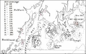
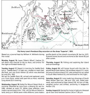
Chart with key showing the route of an excursion on the sloop "Superior" out of Castine made by William H. Witherle, Lane, Stevens and friends during which Lane made several sketches of Mt. Desert scenery. The trip was chronicled by Witherle in his diary of 1852.
View related catalogue entries (6) »
Also filed under: "Superior" (Sloop) » // Castine » // Mount Desert Island & Rock » // Southwest Harbor » // Witherle, William Howe »
Wilson Museum, Castine, Maine.
Library of Congress Catalog Number 2011588006
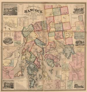
1860 map, including census of towns.
Also filed under: Castine » // Maps » // Mount Desert Island & Rock »
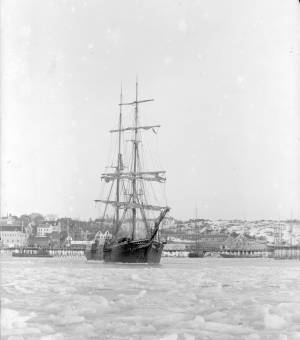
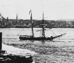
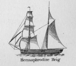
Hermaphrodite brigs—more commonly called half-brigs by American seamen and merchants—were square-rigged only on the fore mast, the main mast being rigged with a spanker and a gaff-topsail. Staysails were often set between the fore and main masts, there being no gaff-rigged sail on the fore mast. (1)
The half-brig was the most common brig type used in the coasting trade and appears often in Lane’s coastal and harbor scenes. The type was further identified by the cargo it carried, if it was conspicuously limited to a specialized trade. Lumber brigs (see Shipping in Down East Waters, 1854 (inv. 212) and View of Southwest Harbor, Maine: Entrance to Somes Sound, 1852 (inv. 260)) and hay brigs (see Lighthouse at Camden, Maine, 1851 (inv. 320)) were recognizable by their conspicuous deck loads. Whaling brigs were easily distinguished by their whaleboats carried on side davits (see ). (2)
– Erik Ronnberg
References:
1. M.H. Parry, et al., Aaak to Zumbra: A Dictionary of the World's Watercraft Newport News, VA: The Mariners’ Museum, 2000), 268, 274; and A Naval Encyclopaedia (L.R. Hamersly & Co., 1884. Reprint: Detroit, MI: Gale Research Company, 1971), 93, under "Brig-schooner."
2. W.H. Bunting, An Eye for the Coast (Gardiner, ME: Tilbury House: 1998), 52–54, 68–69; and W.H. Bunting, A Day's Work, part 1 (Gardiner, ME: Tilbury House: 1997), 52.