An online project under the direction of the CAPE ANN MUSEUM
Catalogue Entry
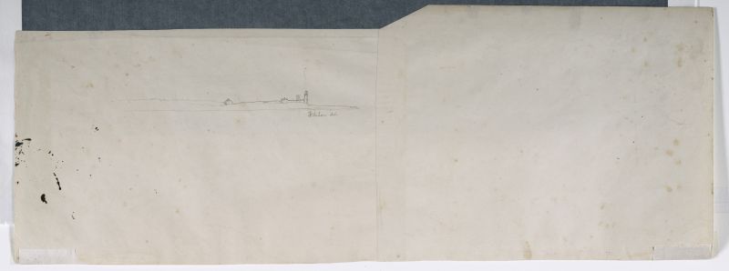
This unfinished drawing depicts Eastern Point and its lighthouse as seen from the north end of Lighthouse Cove, near Black Bess Point. The southern end of Lighthouse Cove is depicted as low ground, extending westward, and partially obscuring the rocky point on which the light house stands.
This image strongly resembles that of Untitled, n.d. (inv. 222) which is the detached left third of Gloucester Outer Harbor, from the Cut, 1850s (inv. 109), the sketch for the painting “Stage Fort across Gloucester Harbor” (Stage Fort across Gloucester Harbor, 1862 (inv. 237)). The surrounding topography, however vestigial, indicates a viewing point further east and closer to the subject. The drawing’s incomplete state indicates that no further progress was made to bring it to paint on canvas.
– Erik Ronnberg
- Subject Types
: - Cape Ann Locales
: - Building Types
:
Historical Materials
Eastern Point is the long promontory that defines the eastern limit of Gloucester Harbor. In Lane's day it was wild and uninhabited but was also a strategic landmark. A Civil War fort was built there in 1863. Lane painted his seminal series of Brace's Cove and Brace's Rock from a vantage point on the eastern side.
The area was made safer for navigation by the construction of a new lighthouse in 1831 and the breakwater known as the Dog Bar. First proposed in 1866 in order to reduce turbulence in the waters of the outer harbor during heavy weather, it was not until 1894 that work on its construction began. Progress was slow, and although an extraordinary number of shipwrecks and groundings in 1898 sped it up somewhat, the breakwater was not completed until 1905.
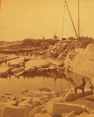
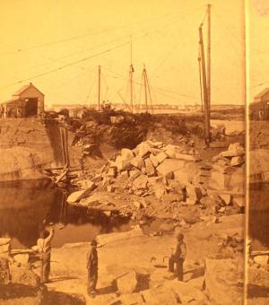
c.1880 Stereograph card Cape Ann Museum Library & Archive
This view shows a wood derrick for hoisting granite blocks.
Also filed under: Granite Quarrying / Shipping » // Historic Photographs »
Glass plate negative from Benham Collection
Cape Ann Museum Library & Archive
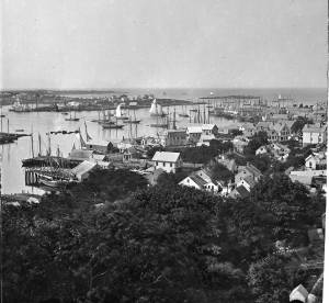
View of Gloucester Harbor from Friend Street Wharves, Five Pound Island segment at far left, Rocky Neck, Eastern Point and Ten Pound Island in background.
Also filed under: Five Pound Island » // Gloucester – City Views »

Engraving of 1819 survey taken from American Coast Pilot 14th edition
9 1/2 x 8 in.
Cape Ann Museum Library & Archive
D32 FF5
Also filed under: Dolliver's Neck » // Maps » // Norman's Woe » // Ten Pound Island »

c.1870 Stereograph card Procter Brothers, Publisher Cape Ann Museum Library & Archive
View from Civil War fort on Eastern Point.
Also filed under: Gloucester Harbor, Outer » // Historic Photographs »
c.1880 Stereograph card Cape Ann Museum Library & Archive
This view shows a wood derrick for hoisting granite blocks.
Also filed under: Granite Quarrying / Shipping » // Historic Photographs »
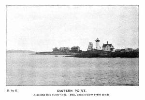
Plate from The Illustrated Coast Pilot with Sailing Directions: The Coast of New England from New York to Eastport, Maine including Bays and Harbors, published by N. L. Stebbins,1896.
Also filed under: Gloucester, Mass. – Eastern Point Light »
Stereograph card
Published by Frank Rowell
Cape Ann Museum Library & Archive
Also filed under: Gloucester, Mass. – Eastern Point Light »

John Heywood Photo for Hervey Friend
Cape Ann Museum Library & Archive (2013.068)
Schooners anchored on the Pancake Ground, taken from from Wonson's Cove, easterly side of the Rocky Neck causeway. Eastern Point Fort and garrison in background to far left.
Also filed under: Gloucester Harbor, Outer »
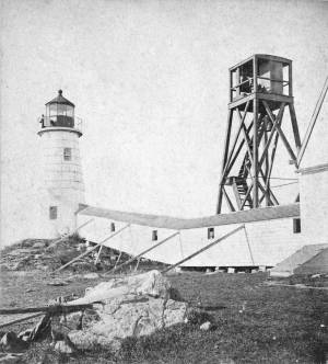
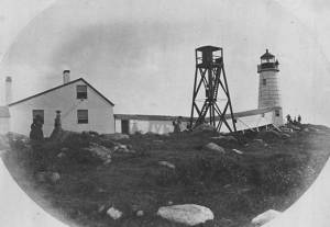
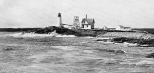
The Eastern Point Light is located in the town of Gloucester, Massachusetts on the east side of the entrance to Gloucester Harbor. In 1829, an unlit stone beacon was erected on Eastern Point to help mariners navigating Gloucester Harbor. Shortly thereafter, in 1832, a wrought-iron and copper lantern was added to the stone tower, and the first Eastern Point Light was born. During the 1840s, Gloucester became one of the most important fishing ports in America, and to cope with the increased fishing traffic, a new Eastern Point Light was built in 1848. The new 34 foot tower gained the nickname "The Ruby Light" due to its unique fixed red light. The Eastern Point Light was further improved upon in the following decades with the addition of a fourth-order Fresnel lens and fog bell.
This information has been shared with the Lane project by Jeremy D'Entremont. More information can be found at his website, www.newenglandlighthouses.net or in The Lighthouse Handbook New England. This information has also been summarized from Paul St. Germain's book, Lighthouses and Lifesaving Stations on Cape Ann.
Photograph U.S. Coastguard
For over 100 years the fishermen of Gloucester have been guided back to their home port by a lighthouse on Eastern Point. The present brick tower, painted a gleaming white, and standing on the long rocky point forming the eastern side of the harbor, was built in 1890, replacing on the same foundation the original tower built in 1832. Before 1832 a still older lighthouse, on Ten-Pound Island well inside of the harbor, had served as an entrance light, but this light was never visible until ships had actually found the entrance, hence the building of a lighthouse on the Eastern Point where it could be seen from far offshore.
Courtesy United States Coast Guard.
Also filed under: Historic Photographs »

Newspaper
"There are quite a number of visitors in town at the present time, who come to spend a few weeks by the seaside, during the sultry weather of August."
Also filed under: Fessenden, C. B. » // Newspaper / Journal Articles » // Procter Brothers – Gloucester, Mass. » // Tourist Industry »
Newspaper clipping
Cape Ann Advertiser
Collection of Fred and Stephanie Buck
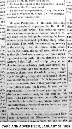
"MARINE PAINTING. – F. H. Lane, Esq., has recently completed a picture for Dr. H. E. Davidson of this town. The painting represents a sunset scene in our harbor, which is taken near the cut bridge, introducing the beach covered with rocks and pebbles, steep bank, and Stage Fort, with the surrounding scenery in the vicinity. . . It is impossible to give an adequate idea of this painting by any description of ours, for it must be seen to be appreciated. It is the largest painting the artist has yet finished, and, in our opinion, his best. The painting is now on exhibition at the Studio, for a short time, where those who are interested in works of art can have an opportunity of viewing it."
Also filed under: Davidson, Dr. Herman Elvas » // Newspaper / Journal Articles » // Studio Descriptions »
Plate from The Illustrated Coast Pilot with Sailing Directions: The Coast of New England from New York to Eastport, Maine including Bays and Harbors, published by N. L. Stebbins,1896.
Also filed under: Eastern Point »
Stereograph card
Published by Frank Rowell
Cape Ann Museum Library & Archive
Also filed under: Eastern Point »
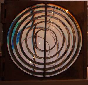
Four circular glass prism lenses in a brass frame:
Lens diameters 19". Base 21" square x 19-1/2" high.
Cape Ann Museum. On permanent loan from the United States Coast Guard, 2013
When installed, the light source was fixed and the lens mount rotated.
Also filed under: Objects »