An online project under the direction of the CAPE ANN MUSEUM
Catalogue Entry
- Subject Types
:
Historical Materials
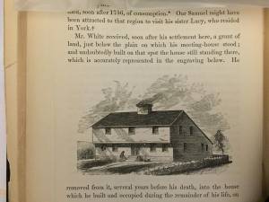
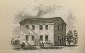
In John J. Babson, History of the Town Gloucester (Gloucester, MA: Procter Brothers, 1860)
See p. 230.
Filed under: Babson History of the Town of Gloucester » // White-Ellery House »
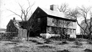
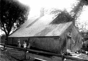
The White-Ellery House was built in 1710 and is one of just a handful of First Period houses in Eastern Massachusetts that survives to this day with much of its interior detail intact. (First Period means c.1620–1725.) It is a two-story “saltbox” structure with a massive central chimney that once serviced six fireplaces. Stepping inside today, visitors enter much the same house they would have 300 years ago.
The White-Ellery House is on the National Register of Historic Sites because of its unique construction and important interior features. The most important elements of the House include the following:
·Vertical plank frame construction.
·A framed overhang on the front façade.
·Elaborate chamfering (decorative plane work) on ceiling beams, particularly on the first floor.
·Three different examples of painted wall decoration.
·Renaissance-inspired architectural features illustrating the transition from European building traditions to early American ones.
·Very rare examples of raised-field paneled doors between rooms on the first floor.
·Unusually elaborate bolection moldings around fireplaces.
·Several examples of original clay plaster (with hair and eel grass), and skim coat of lime plaster.
·An integral lean-to roof (built at the same time as the rest of the structure).
·One of the most highly developed front staircases of the period in Eastern Massachusetts.
The White-Ellery House was built for the Reverend John White (1677–1760), brother-in-law of Cotton Mather, former Chaplain at Fort Saco, author of New England's Lamentations (1734) and Gloucester’s first settled minister. In keeping with White’s esteemed position in the community, the House exhibits a certain elegance and refinement, perhaps best reflected in the surviving interior details.
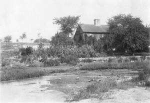
At the time the House was constructed, the surrounding area was Gloucester’s Town Green–the center of the community. The Reverend White’s church, also called a meeting house, was located on the green and most of the townspeople lived in the immediate area. The Annisquam River was readily accessible and was an important means of transportation for early residents, most of whom were farmers or simple tradesmen, and their families.
The second owner of the White-Ellery House was James Stevens who kept it as a tavern between 1735 and 1740. The House was owned next by the Ellery family who retained ownership of it until 1947. Although the center of Gloucester long ago moved from the Town Green to the Harbor Village, the site remains the entrance to Gloucester and an important historical site.
The barn alongside the White-Ellery House is also a First Period structure, built in the mid-1730s, exhibiting the same early construction techniques as the House. Recently it has undergone stabilization work by students in the Preservation Carpentry Program at the North Bennet Street School; further work will focus on preservation of the exterior.
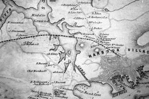
1851 44 x 34 in. Henry Francis Walling, Map of the Towns of Gloucester and Rockport, Essex Co. Massachusetts. Philadelphia, A. Kollner, 1851 Cape Ann Museum Library & Archive
"Map of the Towns of Gloucester and Rockport, Massachusetts. H.F. Walling, Civil Engineer. John Hanson, Publisher. 1851. Population of Gloucester in 1850 7,805. Population of Rockport in 1850 3,213."
Also filed under: Babson House » // Cut, The (Stacy Blvd.) » // Town / Public Landings »
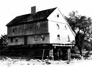
In 1947, plans were unveiled showing the soon-to-be-constructed Rte. 128 coming into Gloucester directly through the Town Green and literally on the doorstep of the White-Ellery House. Realizing the House’s importance, the City of Gloucester took it by eminent domain and sold the building to the Cape Ann Historical Museum with the proviso that it be moved immediately. Under the leadership of Museum president Alfred Mansfield Brooks, the House was picked up and moved approximately 100 yards to its present location. For the next decade, Brooks oversaw restoration of the structure, a process which successfully preserved much of the original fabric of the House and which has allowed visitors today to see this gem of First Period architecture, still standing on the edge of Gloucester’s former Town Green.
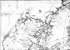
1851 44 x 34 in. Henry Francis Walling, Map of the Towns of Gloucester and Rockport, Essex Co. Massachusetts. Philadelphia, A. Kollner, 1851 Cape Ann Museum Library & Archive
"Map of the Towns of Gloucester and Rockport, Massachusetts. H.F. Walling, Civil Engineer. John Hanson, Publisher. 1851. Population of Gloucester in 1850 7,805. Population of Rockport in 1850 3,213."
Also filed under: Annisquam River » // Babson House » // Coffin's Beach » // Eastern Railroad » // Gloucester, Mass. – Annisquam Harbor Lighthouse » // Granite Quarrying / Shipping » // Loaf, The » // Low (David) House » // Maps » // Old First Parish / Subsequent Fourth Parish Church (at the Green) » // Riverdale Methodist Church (Washington Street) »
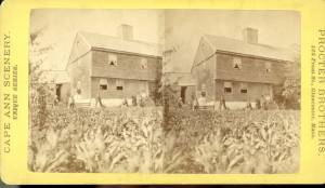
Stereoview card Cape Ann Museum Library & Archive
Also filed under: Historic Photographs »

Video tour of the White-Ellery House, Cape Ann Museum, 2022
This short video tour provides an overview of the White-Ellery House (1710).
This video, along with virtual tours of the Captain Elias Davis House, and the Babson-Alling House were generously funded by a grant from MassHumanities.
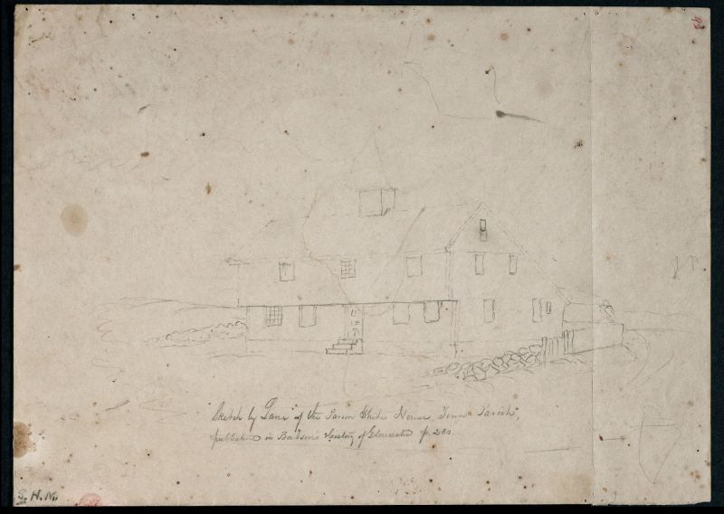
In John J. Babson, History of the Town Gloucester (Gloucester, MA: Procter Brothers, 1860)
See p. 230.
Also filed under: Babson History of the Town of Gloucester »

John J. Babson's History of the Town of Gloucester was published by Procter Brothers in 1860. It provides a brief biography of Lane as well as indicates that Lane drew some of the illustrations for the book; it is unclear whether he drew all or just some.
"Mr. Lane was born Dec. 18, 1804. At the age of eighteen months, while playing in the yard or garden of his father, he ate some of the seeds of the apple-peru; and was so unfortunate as to lose the use of his lower limbs in consequence, owing to late and unskilful medical treatment. He showed in boyhood a talent for drawing and painting; but received no instruction in the rules till he went to Boston, at the age of twenty-eight, to work in Pendleton's lithographic establishment. From that time, his taste and ability were rapidly developed; and, after a residence of several years in Boston, he came back to Gloucester with a reputation fully established. Since his return to his native town, he has painted many pictures, all of which have been much admired. He has often contributed a production of his pencil for the promotion of a benevolent enterprise; and, with characteristic kindness, he furnished the sketches for the engravings in this work."
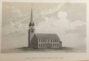
See p. 498. This shows the First Parish Meeting House before it was rebuilt in 1828.
Also filed under: Unitarian Church / First Parish Church (Middle Street) »

In John J. Babson, History of the Town Gloucester (Gloucester, MA: Procter Brothers, 1860)
See p. 230.
Also filed under: White-Ellery House »
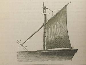
See p. 254.
As Erik Ronnberg has noted, Lane's engraving follows closely the French publication, Jal's "Glossaire Nautique" of 1848.
Also filed under: Schooner (Fishing) »
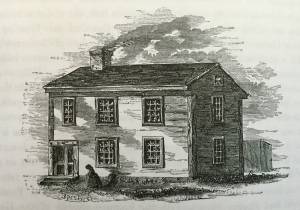
See p. 266.
Also filed under: Second Parish Meeting House (West Gloucester) »
Marks: Inscribed upper left (in red ink): 92 [numbering system used by curator A. M. Brooks upon Samuel H. Mansfield's donation of the drawings to the Cape Ann Museum]