An online project under the direction of the CAPE ANN MUSEUM
Catalogue Entry
- Subject Types
: - Vessel Types
: - Sloop »
Historical Materials
Preceded by Annisquam as the earliest permanently settled harbor and Gloucester’s original first parish, Gloucester Harbor did not become a seaport of significance until the end of the 17th century. Its earliest fishing activity was focused on nearby grounds in the Gulf of Maine, few vessels venturing further to the banks off Canada. After 1700, as maritime activity was well-established in fishing, shipbuilding, and coastal trade, the waterfront saw the expansion of flake yards for drying fish and wharves for berthing and outfitting vessels, loading lumber and fish, and receiving trade goods. Shipbuilding was also carried on, using shorelines with straight slopes not suited for wharves.
By 1740, the majority of Cape Ann-owned vessels were berthed in Gloucester Harbor; three years later, Watch House Point (now called Fort Point) was armed and fortified. The fishing fleet continued to grow, numbering over 140 vessels by the time of the Revolution. A customs office was established in 1768, resulting in strong protests over seizures of contraband. Revolution brought hardship to the fishing industry, forcing many vessel owners to resort to privateering.
Independence saw a much-diminished fishing fleet and a severely impoverished seaport. With the Federally-sponsored incentive of the codfish bounties, Gloucester fishermen began to rebuild their fishing fleet. By 1790, trade with Surinam was under way, leading to the building and purchase of merchant vessels, new wharves, and improvements to old wharves in Harbor Cove, which had become Gloucester’s center of maritime activity. In addition to shipyards and sail lofts, two ropewalks furnished cordage for rigging.
The first four decades of the 19th century saw fitful growth in the fishing industry, due to the interruptions of war and financial panics. Few wharves were added to the waterfront in that period, and when new ones were built, their purpose was to serve the growing Surinam Trade. Fishing had come to its low point in the 1840s when the railroad reached Gloucester, opening a huge inland market for the fish it caught. The use of ice to keep fish fresh, combined with new and faster fishing schooners to get it quickly to port, sparked a revival in Gloucester’s fishing industry.
As Gloucester’s fishing industry revived, its growth in the Surinam Trade was hampered by its shallow harbor which made berthing of ever larger ships more difficult. Forced to seek a deeper harbor, merchants reluctantly sent their largest ships to Boston for unloading. Between 1850 and 1860, this process continued until ships and warehouses were relocated and their owners commuted to Boston by rail, leaving their old wharves to the fishing fleet. In 1863, the Surinam trade collapsed.
Gloucester’s fishing fleet grew dramatically in the 1850s for more reasons than ice, railroads, and faster schooners. The technology of catching fish also improved dramatically. Hand-line fishing (two hooks on a line) gave way to dory trawling with many hooks on a very long “trawl line,” while fishing for mackerel with hand-lines was replaced by “purse seining,” setting a 1,000-foot-long net in a circle around a school of mackerel. These dramatic improvements in productivity were expensive but made possible by the fishermen organizing a mutual savings bank to serve their needs and a mutual insurance company to cover their risks. These advantages could not be matched by any other fishing communities in New England or in the Canadian Maritime Provinces, sparking a huge migration of fishermen to Gloucester. These newcomers were welcomed to fill a growing work force while Gloucester’s native work force moved on to other, less dangerous, occupations.
Lane’s depictions of Gloucester’s waterfront best illustrate the period before 1850. After that date, his attention turned more to the Harbor’s outer shores, to nearby communities such as Manchester, to New York, back to Boston, and north to Maine. While his lapse of interest is regrettable, the scenes and activity he missed were becoming popular with photographers while his earlier waterfront views are nowhere else to be found.
–Erik Ronnberg
References:
Dates and happenings were based on (or confirmed by):
Mary Ray and Sarah V. Dunlap, “Gloucester, Massachusetts Historical Time-Line (Gloucester: Gloucester Archives Committee, 2002).
Improvements to Gloucester’s fishing technology, management, and financing are based on:
Wayne O’ Leary, “Maine Sea Fisheries” (Boston: Northeastern University Press, 1996), pp. 166–179 (fishing technology), 235–251 (management and financing), and 235–251 (in-migration to Gloucester).

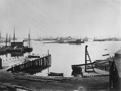
1876 Photograph Cape Ann Museum Library & Archive
Also filed under: Gloucester Harbor, Inner / Harbor Cove » // Historic Photographs » // Schooner (Fishing) »

1876 Photograph Cape Ann Museum Library & Archive
Ignatius Weber's windmill (now defunct) is shown.
Also filed under: Flake Yard » // Fort (The) and Fort Point » // Gloucester Harbor, Inner / Harbor Cove » // Historic Photographs » // Rogers's (George H.) wharves » // Schooner (Fishing) » // Windmill »

44 x 34 in.
John Hanson, Publisher
Cape Ann Museum Library & Archive
"Map of the Towns of Gloucester and Rockport, Massachusetts. H.F. Walling, Civil Engineer. John Hanson, Publisher. 1851. Population of Gloucester in 1850 7,805. Population of Rockport in 1850 3,213."
Also filed under: Fort (The) and Fort Point » // Low (Frederick G.) wharves » // Maps » // Rogers's (George H.) wharves » // Town / Public Landings » // Windmill »
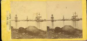
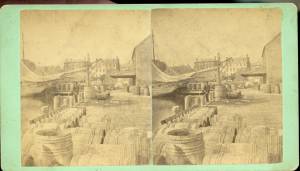
c.1875 Stereograph card Cape Ann Museum Library & Archive
This view of Gloucester's Inner Harbor shows three square-rigged vessels in the salt trade at anchor. The one at left is a (full-rigged) ship; the other two are barks. By the nature of their cargos, they were known as "salt ships" and "salt barks" respectively. Due to their draft (too deep to unload at wharfside) they were partially unloaded at anchor by "lighters" before being brought to the wharves for final unloading.
– Erik Ronnberg
Also filed under: Bark / Barkentine or Demi-Bark » // Historic Photographs » // Salt »
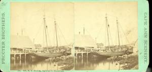
1870s Stereograph card Cape Ann Museum Library & Archive
"Said schooner was captured about the first of September, 1871, by Capt. Torry, of the Dominion Cutter 'Sweepstakes,' for alleged violation of the Fishery Treaty. She was gallantly recaptured from the harbor of Guysboro, N.S., by Capt. Harvey Knowlton., Jr., (one of her owners,) assisted by six brave seamen, on Sunday night, Oct. 8th. The Dominion Government never asked for her return, and the United States Government very readily granted her a new set of papers."
Also filed under: Fishing » // Historic Photographs » // Schooner (Fishing) »

1876 Stereograph card Cape Ann Museum Library & Archive
Stereo view showing Gloucester Harbor after a heavy snowfall
Also filed under: Gloucester Harbor, Inner / Harbor Cove » // Historic Photographs »
Wood, metal, and paint
20 1/4 x 10 1/4 x 10 1/2 in., scale: 1/2" = 1'
Made for the Columbian Exposition, Chicago, 1892–93
Cape Ann Museum, from Gloucester Chamber of Commerce
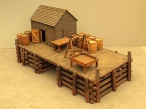
The wharf is built up of "cribs", square (sometimes rectangular) frames of logs, resembling a log cabin, but with spaces between crib layers that allow water to flow freely through the structure.Beams are laid over the top crib, on which the "deck" of the wharf is built. Vertical pilings (or "spiles" as locally known) are driven at intervals to serve as fenders where vessels are tied up.
– Erik Ronnberg
Also filed under: Cob / Crib Wharf »
Stereograph card Cape Ann Museum Library & Archive
Also filed under: Fishing » // Historic Photographs »

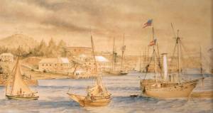
c.1870 Cape Ann Museum Library & Archive (2013.068)
Schooner fleet anchored in the inner harbor. Looking east from Rocky Neck, Duncan's Point wharves and Lane house (at far left), Sawyer School cupola on Friend Street.
Also filed under: Duncan's Point » // Gloucester Harbor, Inner / Harbor Cove » // Historic Photographs » // Schooner (Fishing) »
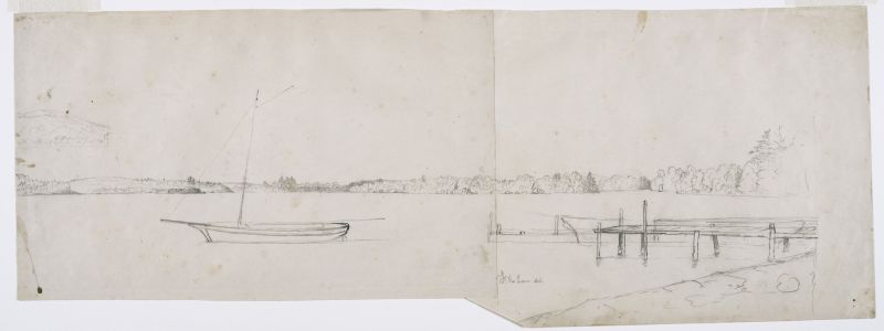
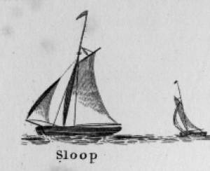
Sloops are one-masted sailing vessels which, in American examples, set fore-and-aft sails but usually no square sails. Thus, staysails, or jibs, are set from the fore stay(s) and a quadrilateral mainsail is set from the mast and spread by a gaff and a boom. The larger sloops would often set a triangular topsail over the main sail. (1)
The sloops depicted by Lane were used in various coastal trades, each with its own requirements, which dictated the sizes and details of their hulls and rigs. Most elegant were the packet sloops, which transported passengers, mail, and higher value goods between specific ports on regular schedules. They usually measured between sixty and seventy-five feet on deck, as dictated by anticipated shipping volume. Finely finished, they usually had stern galleries—a row of windows across the transom with ornamental moldings—and varied color schemes. Examples of packet sloops are in Gloucester Harbor from Rocky Neck, 1844 (inv. 14) (center, middle ground) and Study of Ships, 1851 (inv. 141) (foreground), both of which probably made trips between Gloucester and Boston, or Gloucester and Newburyport. (2)
Another specialized sloop of similar size was the stone sloop, used to ship granite blocks from stone-loading piers around Cape Ann to other ports. They were similar in rig to packet sloops, but of heavier construction with greater hold capacity and absence of decoration. Their stout appearance was augmented by simple color schemes, or even tarred topsides, reflecting the wear and strain imposed by their heavy cargos. Lane depicted these vessels in his painting of Fresh Water Cove from Dolliver's Neck, Gloucester, Early 1850s (inv. 45), with a sloop (at left) preparing to load at wharf-side, and another (at right) sailing out with a cargo. (3)
Sloops of the more work-a-day sort are the most commonly seen examples in Lane’s paintings, most of them appearing in his views of Boston Harbor. Usually deep-loaded and looking weather-worn, they contrast sharply with the packet- and clipper ships which dominate the scene. Sloops of this type are rarely seen in Lane’s paintings of Gloucester Harbor and the Maine coast, although they were certainly needed for short-distance transportation (see Bear Island, Northeast Harbor, 1855 (inv. 24), View of Camden Mountains from Penobscot Bay, c.1852 (inv. 207), Sunrise on the Maine Coast, Mount Desert Island, 1856 (inv. 295)). For coastal Maine, lack of railroads for heavier freight and greater distances between ports made the use of schooners with larger carrying capacity a greater necessity. (4)
In Lane’s views of New York Harbor, a regional sloop variant, the Hudson River Sloop, appears in New York Harbor, c.1855 (inv. 46) (bow view, left) and A Calm Sea, c.1860 (inv. 6) (stern view, right). This type had become prominent in the Hudson River packet trade between New York City, Albany, and beyond to points north and west as far as the eastern terminus of the Erie Canal. Large vessels for their rigs, they were well-finished and well-kept, reflecting pride of ownership and rivalry among their owners and crews. (5)
– Erik Ronnberg
References:
1. A Naval Encyclopaedia (Philadelphia: L.R. Hamersly & Co., 1884. Reprint: Detroit, MI: Gale Research Company, 1971), 59. See first definition of "sloop" and definition of "sloop-rigged."
2. Robert Greenhalgh Albion, William A. Baker, and Benjamin Woods Labaree, New England and the Sea (Mystic, CT: Mystic Seaport Museum, 1972; reprinted in 1994), 127–28.
3. Howard I. Chapelle, The History of American Sailing Ships (New York: W.W. Norton & Co., 1935), 300–02.
4. Ibid., 300.
5. Ibid., 298–300.
A Naval Encyclopaedia:
Dictionary of nautical words and phrases
Special Articles on Naval Art and Science
Philadelphia: L.R. Hamersly & Co.
'Mudian, "Mugian, or Bermudian. A boat special to the Bermuda islands, usually decked, with the exception of a hatch; from 2 to 20 tons burden; it is short, of good beam, and great draft of water abaft, the stem and keel forming a curved line. It carries an immense quantity of ballast. Besides a long main- and short jib-boom, it has a long, taperking, raking mast, stepped just over the forefoot, generally unsupported by shrouds or stays; on it a jib-headed mainsail is hoisted to a height of twice, and sometimes three times, the length of the keel. This sail is triangular, stretched at its foot by a long boom. The only other sail is a small foresail or jib. They claim to be the fastest craft in the world for working to windward in smooth water, it being recorded of one that she made five miles dead to windward in the hour during a race; and though they may be laid over until they fill with water, they will not capsize.
St. George's Historical Society
Detail of painting of St. George's Harbour, Bermuda, during US Civil War, with a Confederate blockade runner anchored in the foreground.
Also filed under: Puerto Rico »
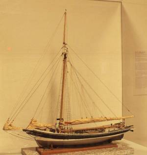
Wood, metal, cordage, cloth, paint.
Scale: ¼ in. = 1ft. (1:48)
Cape Ann Museum. Gift of Roland and Martta Blanchet (1997.17.3)
Although built in 1890 and larger than the stone sloops of Lane’s time, the "Albert Baldwin’s" hull form, rig, and loading boom are very similar to those of the 1840s and 1850s.
Also filed under: Granite Quarrying / Shipping » // Ship Models »

Marks: Inscribed upper left (in red ink): 70 [numbering system used by curator A. M. Brooks upon Samuel H. Mansfield's donation of the drawings to the Cape Ann Museum]