An online project under the direction of the CAPE ANN MUSEUM
Catalogue Entry
- Subject Types
: - Maine Buildings & Locales
: - New England Locales
: - Maine »
- Building Types
:
Historical Materials
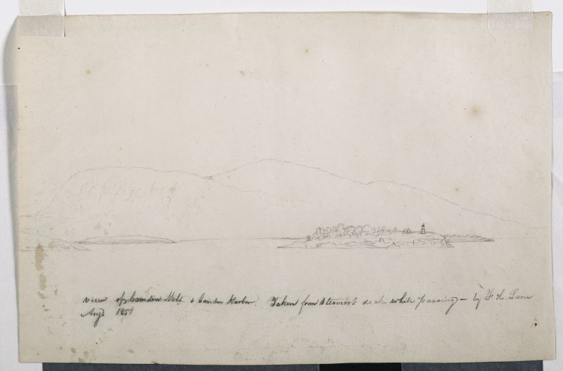
The Camden Mountains, also called the Camden Hills, are located just northeast of the town of Camden. The range includes Mount Megunticook, upon whose shoulders Mount Battie sits, Cameron Mountain, and Bald Rock Mountain. They stand high above West Penobscot Bay between Camden and Lincolnville, looking east toward Mount Desert and the rising sun. The Wabenaki, loosely defined as the "people of the dawn," greeted their maritime world, "the dawn land," from the Camden Hills, and other high points, including Mount Wallamatogus in Penobscot (460 feet), Awan-adjo (at Bluehill), Caterpillar Hill in Sedgwick (with its panoramic sweep which stretches from the Camden Hills to Mount Desert and far out into Penobscot Bay), and atop Cadillac Mountain, Mount Desert. It is from the same peaks that artists and pilgrims alike still climb to view Penobscot Bay.
Mad-kam-ig-os'-sek, "big high land," is the Wabenaki word for Camden, and Meg-un-ti-cook, "big mountain harbor," the name for the harbor, is now used for Mount Megunticook. The inner harbor, quiet and safe, would have been the ideal place for a large, oceangoing canoe to lay up when the sea was rough. Capt. John Smith visited this place in 1614, during the Beaver Wars, and noted that the high mountains were used as a refuge from the Mik'maq of the Maritimes who fought the Wabenaki of Penobscot Bay to maintain their place as middlemen in the fur trade. These raiders would travel along the Downeast coast in their shallops. Mount Battie, of many spellings, was noted as Mount Betty in documents dating from 1757. It is a European corruption of a word borrowed from another place, the Madambettox Hills of Rockland.
-Mark Honey
References:
Eckstorm, Fannie Hardy, "Indian Place-Names of the Penobscot Valley and the Maine Coast," University of Maine Studies, 2nd Series, #55, November 1941, reprinted 1960 by the University of Maine Press. DeLorme's Atlas. Frank G Speck's "Penobscot Man," University Of Pennsylvania Press, 1940.
Newsprint
Gloucester Telegraph
"The Reef of Norman's Woe ... is now commemorated in painting too, one of the finest pictures from Lane's easel. ... The sketch was made at the pretty spot commonly called, we believe, Master Moore's Cove. Being some little way off the main track to Rafe's Chasm, it is seldom visited, except by the more inquisitive lovers of nature who leave the beaten road to pry out such pleasant places. ... We wish it might find a home buyer, rather than go off to enrich another community." Flowery description follows, then "There is another and larger work in the artist's studio, which, happily, is to be retained. It received much well deserved notice and commendation. The subject is a view southward from the 'Cut,' with the picturesque promontory commonly known as 'Stage Fort,' and historically interesting as the supposed spot of the 'Landing at Cape Ann' in the middle distance, and Eastern Point on the extreme left." More description follows, "Among other attractions of the studio, and particularly worthy of mention, is a cabinet picture with an effect similar to the Norman's Woe. The subject is chosen from the many sketches of the grand scenery of the Maine sea-coast with which the artist's portfolio is rich. It is a view of the Camden mountains sketches from the Graves, a jagged ledge far out in the bay, which is accessible in only the smoothest water."
Also filed under: Cut, The (Stacy Blvd.) » // Newspaper / Journal Articles » // The Graves »
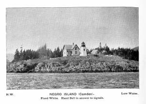
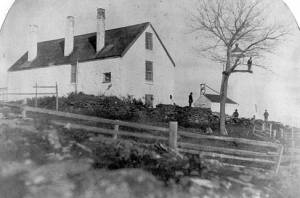
Curtis Island is located a short distance from Camden Harbor in Penobscot Bay. The island was known as Negro Island, from Revolutionary times to the 1930s, and in the early part of the nineteenth century as Mark Island. Abraham Ogier, in a deposition submitted in 1832, claimed that he had pastured hogs on the island and planted potatoes as early as 1773, and that he was driven off by the British in 1779. His grandson Lewis pastured sheep here for 40 years. The island was sold to the US government for a light station for $400 in 1835, and the Negro Island Light was established by an appropriation of $4500 in 1836. M.K.M. Bowers was the light keeper when Lane portrayed the island at dawn. The island was renamed Curtis Island in 1934 after Cyrus H.K. Curtis, publisher of the "Saturday Evening Post," a longtime summer resident and benefactor of Camden.
– Mark Honey
Reference:
McLane, Charles B, and McLane, Carol Evarts, "Islands of the Mid-Maine Coast," Penobscot Bay, Volume 1, Revised Edition, Tilbury House, Publishers, Gardiner, Maine, and the Island Institute, Rockland, Maine, page 124.
Photograph
From book "The Illustrated Coast Pilot with Sailing Directions. The Coast of New England from New York to Eastport, Maine including Bays and Harbors." Published by N.L. Stebbins, Boston, Mass. 1891
Also filed under: Camden, Maine – Negro (Curtis) Island Light »
Photograph
National Archives
Also filed under: Camden, Maine – Negro (Curtis) Island Light »
The Curtis Island Light is located on the seven-acre Curtis Island, a short distance off the coastline of Camden, Maine in the Penobscot Bay. The island was formerly known as Negro Island because the African-American cook of early settler, James Richards, admired the island greatly, but was later named Curtis Island in memory of Camden summertime resident, Cyrus H. K. Curtis. The original lighthouse was built in 1835 by contractor George Gault. Fifteen years later, an inspection report from 1850 stated that the lighthouse needed "immediate attention" and in 1855 the lighthouse was given a wooden outer sheath and new shingling in an attempt to stop the leaks. Lane painted the Curtis Island Light on at least two separate occasions, in 1852 and 1855, during his trips to the Maine coast.
This is information has been shared with the Lane project by Jeremy D'Entremont. More information can be found on his website, www.newenglandlighthouses.net and in his book The Lighthouse Handbook of New England.
Photograph
From book "The Illustrated Coast Pilot with Sailing Directions. The Coast of New England from New York to Eastport, Maine including Bays and Harbors." Published by N.L. Stebbins, Boston, Mass. 1891
Also filed under: Negro (Curtis) Island, Camden Harbor »
Photograph
National Archives
Also filed under: Negro (Curtis) Island, Camden Harbor »